Remnants of Tropical Cyclone Maila Trigger Widespread Rainfall Alert
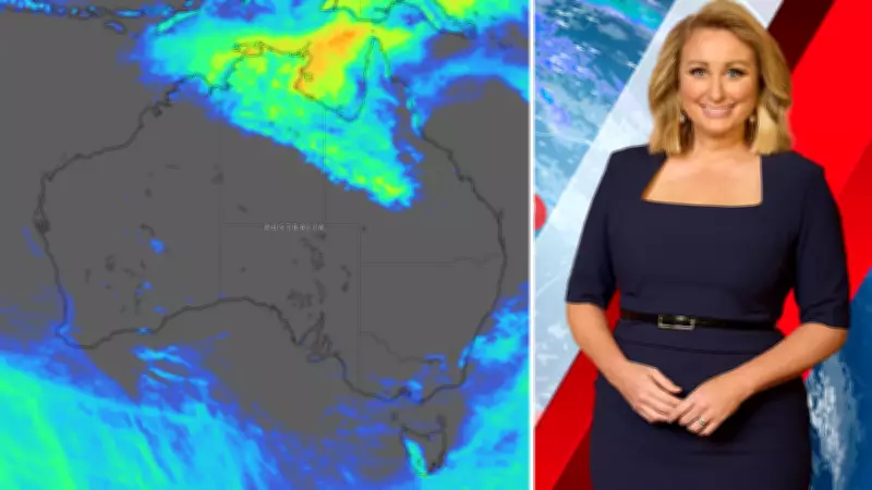
This week's weather map reveals a seemingly innocuous low-pressure system situated at the tip of the Cape York Peninsula, registering a mild 1006hPa. However, this system is far from ordinary—it is the lingering remains of Tropical Cyclone Maila, which less than a week ago intensified into a formidable category 5 cyclone, the highest classification on the scale.
While Maila has shed its terrifying winds and storm surges, it retains a significant moisture payload. Positioned at the northernmost point of the Peninsula, the rain associated with this ex-cyclone is projected to extend broadly over the northern half of Queensland and into the Northern Territory.
Substantial Rainfall Forecasted for Northern Regions
Over the coming days, meteorologists anticipate rainfall exceeding 50mm across an extensive area, with some locales likely to experience accumulations well over 100mm. As the wet season approaches its conclusion, such precipitation events are becoming increasingly rare in tropical zones, potentially positioning this as a final seasonal outburst.

The weather pattern observed on Wednesday morning, as documented by the Bureau of Meteorology, underscores this developing scenario. Concurrently, projections for potential rain in the subsequent days, credited to 7NEWS, highlight the widespread impact expected from this moisture surge.
Agricultural Implications and Seasonal Weather Shifts
Farmers in southern regions monitor these systems with keen interest, particularly during April and May, traditionally known as "the break." This period marks the dissolution of high-pressure systems that dominate summer weather, allowing stronger low-pressure systems to traverse the area.
This transition signals a shift from predominantly dry conditions to a resurgence of regular rainfall. For effective precipitation, low-pressure systems—manifesting as fronts, troughs, or proper lows—require a critical component: moisture.
The Crucial Role of Tropical Moisture in Rainfall Production
When a front or trough originates from the Southern Ocean and moves over southern Australia, it carries moisture from that ocean. However, with ocean temperatures ranging from 10°C to 15°C, the air above absorbs limited moisture, resulting in diminished rainfall inland from standard troughs or cold fronts.
In contrast, tropical oceans, with temperatures between 20°C and 30°C, infuse the air with substantially more moisture. This disparity is palpable, akin to the contrast between stepping off a plane in dry Melbourne versus humid Cairns.
If tropical moisture feeds into a trough or front, it can generate extensive, soaking rains that penetrate inland, rather than being confined to coastal areas. Over the next five to eight days, the current tropical moisture surge from ex-Cyclone Maila is not expected to connect with systems crossing the south. Nonetheless, it remains prudent to monitor these remnants for potential linkages in the future.