Cyclone Narelle's Perth Soaking Threat Eases, But Heavy Rain Still Looms
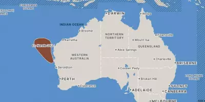
Perth's feared record-breaking drenching from tropical cyclone Narelle has been dialled back — but the city is still in line for a solid soaking as the system barrels down the WA coast. Forecasters say shifting models have spared Perth the worst, with the powerful system hugging the coast and now expected to head inland near Coral Bay, rather than tracking closer to the metro area as earlier feared.
A Change in Forecast Brings Relief, But Not Dryness
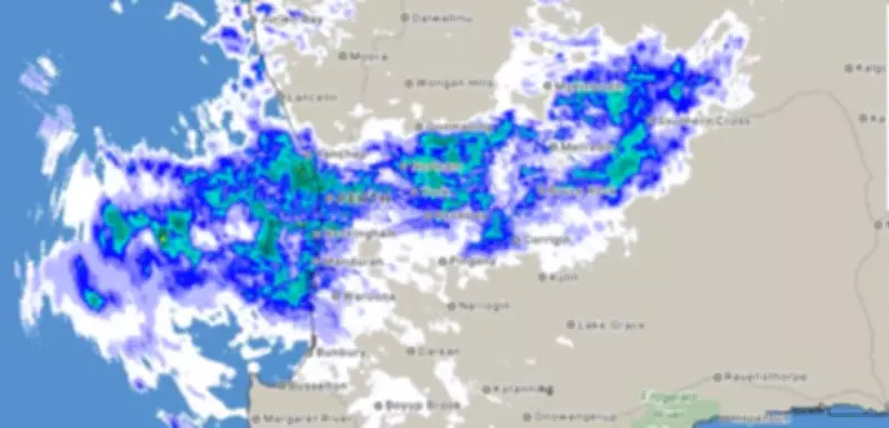
It's a change that could prove the difference between a historic deluge — and just a very wet day. However, residents are advised not to put the umbrella away just yet. Bureau of Meteorology senior meteorologist Jonathan How emphasised that Perth would still be hit by rain dragged in from a massive cloud band streaming off the cyclone.
"Perth itself won't miss out," he said. "There's quite a big cloud band pouring down from Narelle at the moment and that's what's leading to the rain across the city right now."

Rainfall Predictions and Record-Breaking Potential
Up to 40mm is forecast for Friday, with totals possibly pushing 50mm — and even higher if storms fire over the metro area. The heaviest falls are expected east of Perth, where isolated totals could hit 70mm. While the city is unlikely to break its long-standing March daily rainfall record of 77mm set in 1934, it is not completely off the table.
"We're not expecting that generally today," Mr How stated. "But you couldn't rule it out if we do get a storm moving down — there's a lot of moisture."
Moisture and Flash Flooding Risks
And it is the moisture that is the wildcard. A tropical, humid air mass feeding into the system means any thunderstorms could dump intense, localised bursts of rain, with a risk of flash flooding if one parks over the city. This adds an element of unpredictability to the weather event, despite the reduced overall threat.
Weekend Outlook and System Movement
By Saturday, the focus shifts away from Perth. The weakening system is expected to move south-east across the State, with the heaviest rain targeting the Wheatbelt and inland regions where falls of up to 50mm are predicted. Perth will still see rain — about 20–40mm — but not as intense as originally believed.
By early Sunday, the system is tipped to race off the south coast between Albany and Esperance, weakening into a tropical low. Showers will linger but the worst will be over, providing some respite for residents after a wet and windy period.