Cyclone Narelle Intensifies as It Heads Towards Northern Territory
Cyclone Narelle, one of the most powerful storms to hit Australia in recent years, is currently churning towards the Northern Territory after making a significant landfall in Queensland as a category four system. The weather event, now downgraded to a category two, moved westwards over the Cape York Peninsula on Friday night. It is expected to quickly barrel across the Gulf of Carpentaria, strengthening back to a category three by approximately 10am on Saturday.
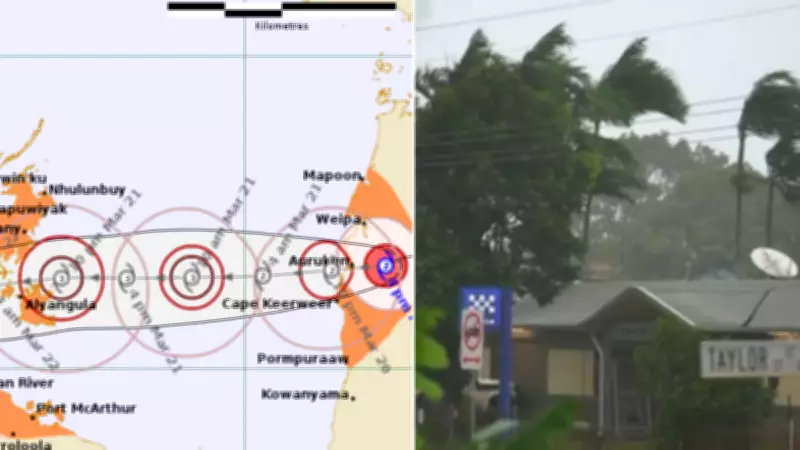
Expected Path and Impact on the Top End
Narelle is forecast to approach the northeast of the Northern Territory on Saturday, likely crossing the Top End's coast overnight Saturday or early Sunday morning between Birany Birany and Ngukurr as a category three cyclone. Following this, the system will weaken as it moves inland across the Top End on Sunday and Monday, but not before unleashing severe conditions.
The Top End has been issued urgent warnings, with wind gusts of up to 195km/h predicted to develop in areas including Birany Birany, Numbulwar, and Groote Eylandt from Saturday evening into Sunday. Additionally, gales of up to 120km/h are expected between Gapuwiyak and Port McArthur, encompassing Nhulunbuy and Borroloola, from Saturday afternoon and may extend west to Ramingining, Bulman, and Ngukurr by Sunday.

Flooding and Storm Tide Threats
Heavy rainfall is likely to develop between Port McArthur and south of Nhulunbuy from Saturday afternoon, potentially causing dangerous and life-threatening flash flooding in the evening. There is also a risk of a potentially dangerous storm tide between Alyangula and Port Roper as the cyclone centre crosses the coast, which could lead to damaging waves and further flooding incidents.
Northern Territory Emergency Services have advised residents in affected zones to take immediate action. "People between Nhulunbuy and Port McArthur, including Borroloola, Numbulwar, Alyangula, and Gapuwiyak, should immediately commence or continue preparations, especially securing boats and property," the warning states. "People further west including Ramingining, Bulman, and Ngukurr, should consider what action they will need to take if the cyclone threat increases."
Evacuations and Damage Reports
In response to the approaching cyclone, the defence force has evacuated almost 150 people from the Northern Territory community of Numbulwar, with hundreds more set to be flown out. Overall, about 500 individuals are expected to seek shelter in a Darwin high school gymnasium in the coming days to ride out Narelle's wrath.
As the cyclone moved across Queensland on Friday night, it brought destructive wind gusts of up to 130km/h near the centre and heavy rainfall, along with risks of large waves and minor flooding in low-lying coastal areas. The Bureau of Meteorology emphasized the importance of safety, advising people in the cyclone's path to "stay calm and remain in a secure shelter - above the expected water level - while the destructive winds continue." They also cautioned against venturing outside during the eye of the cyclone, as destructive winds could resume from a different direction at any time.
Minimal Damage in Queensland but Ongoing Risks
When Narelle made landfall on an unpopulated stretch of the Cape York coastline on Friday morning, the damage was less severe than anticipated. However, it still caused incidents such as a roof being ripped off a home in Coen and fallen branches. Queensland Premier David Crisafulli noted, "There is some structural damage and there are some trees down, but overwhelmingly the damage has been relatively minimal."
In affected areas like Portland Roads, north of Lockhart River, residents experienced relentless winds, with one reporting, "The wind is just relentless and really gusting." Further south, Cairns faced a storm surge and cyclonic swells, leading to erosion at Holloways Beach and challenging surf conditions at Kewarra Beach, where a surfer remarked, "I've been here my whole life... Never seen a lot like this before."
During its 11-hour journey across the peninsula, the cyclone's primary impact so far has been power outages, with ongoing rainfall causing rapid river rises, such as the Archer River increasing from 5 metres to 13 metres.