Cyclone Narelle: Emergency Chiefs Warn Storm Still Packing a Punch and to Stay Inside if Near the Eye
Emergency authorities have issued a stern warning that Cyclone Narelle continues to pose a significant danger, urging residents in affected areas to remain indoors as the storm system moves southward. The town of Exmouth has been severely impacted, with wind gusts reaching 200km/h at Learmonth airport and 200mm of rain falling within six hours.
Severe Damage and Ongoing Threats
Department of Fire and Emergency Services commissioner Darren Klemm stated that Narelle is the most powerful cyclone to hit Exmouth since Cyclone Vance in 1999. The town experienced widespread power outages on Friday afternoon, with numerous reports of roof damage and water ingress across the Pilbara and Midwest-Gascoyne regions. Fortunately, no injuries have been reported so far.
Mr Klemm emphasized that while the eye of the cyclone has passed, Exmouth remains under an emergency warning, likely to persist until mid-afternoon. He highlighted the complexity of the storm, describing it as incredibly large and difficult to manage, with a dedicated team working to ensure accurate and timely warnings.

Evacuation Challenges and Community Response
An evacuation centre in Exmouth had to be evacuated after its roof peeled off, forcing dozens of sheltering individuals to seek safety at a nearby church. Premier Roger Cook expressed solidarity with residents, acknowledging their resilience while urging everyone to heed official warnings.
In Karratha, a watch and act alert remains in place, causing some confusion among locals who expected a lockdown. Mr Klemm addressed concerns about the warning system transition, noting teething issues as authorities adapt to the new Australia warning system.
Storm Progression and Regional Impacts
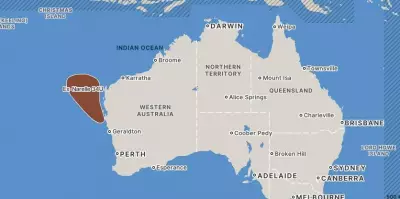
As Cyclone Narelle heads south, it is expected to weaken from a category 4 system between Coral Bay and Cape Cuvier. Bureau of Meteorology expert James Ashby predicted it will likely remain a category three cyclone as it moves inland near Carnarvon and Shark Bay, with Geraldton potentially experiencing damaging winds into Saturday.
Heavy rain in Perth is forecast to ease by Saturday afternoon. Evacuation centres have been established in Shark Bay and Carnarvon to accommodate displaced residents. Authorities continue to monitor the situation closely, emphasizing the importance of staying informed and following safety protocols.