
Australia is currently gripped by a dramatic weather divide, with the nation's north bracing for potential cyclones and deluges of rain, while the southeast endures a severe and persistent heatwave that is dramatically increasing bushfire risks.
Cyclone Threat Looms for Saturated Queensland
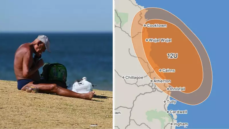
Far North Queensland, already waterlogged from recent heavy rainfall, is now preparing for even more extreme conditions. A tropical low developing in the Coral Sea has a moderate chance of forming into a tropical cyclone, which would be named Tropical Cyclone Koji.
The Bureau of Meteorology warns this system is drawing moisture and energy from warm ocean waters and is forecast to move towards the northeast Queensland coast, likely crossing on Friday or Saturday. Meteorologist Helen Reid stated heavy rainfall is expected to develop during Friday and continue into Saturday.

Forecasters predict six-hourly rainfall totals between 100mm to 150mm, with isolated falls potentially exceeding 200mm. Areas from Cooktown to the Whitsundays are on alert, with locations like Cairns, Port Douglas, Ingham, and Townsville at particular risk of dangerous flash-flooding due to the already saturated ground.
Meanwhile, in the west, Tropical Cyclone Jenna is weakening over the Indian Ocean and moving away from the Cocos (Keeling) Islands. Another tropical low is being monitored in the Gulf of Carpentaria, but currently poses a very low cyclone risk.
Scorching Heatwave Fuels Bushfire Danger in Southeast
While the north faces a deluge, the southeastern states are battling a severe and extended heatwave. Temperatures that soared into the high 40s Celsius on Wednesday are forecast to continue on Thursday and into the weekend, creating tinderbox conditions.
Fire crews are on high alert across Victoria, South Australia, New South Wales, and the ACT. The hot, dry, and windy conditions have prompted widespread bushfire warnings and public health alerts to avoid heat stroke.
Evacuation alerts have already been issued for parts of Victoria, and emergency warnings remain for ongoing fires in Western Australia. The fire danger is expected to peak on Friday due to the combination of extreme heat and wind.
Key forecast temperatures for Thursday include:
- Port Augusta, SA: 47°C
- Mildura, Victoria: 46°C
- Sydney's west: 40°C
- Canberra: 38°C (first of three extreme heat days)
- Adelaide: 38°C
Melbourne is expecting a slightly cooler 31°C on Thursday before the heat returns with a vengeance, forecast to hit 41°C on Friday. A cooler change is due to reach southern coastal areas on Friday afternoon, but Sydney city may still swelter through 42°C on Saturday before relief arrives.
Heatwave Extends to Tasmania and the Interior
The extreme conditions are not confined to the mainland southeast. Tasmania is under severe heatwave warnings for multiple regions, including the North East and East Coast, with an extreme warning for the Furneaux Islands.
In Western Australia, while Perth enjoys a fine 28°C, severe heatwave conditions continue in the north, with parts of the Pilbara and Gascoyne expecting maximums in the high 40s.
The Northern Territory's interior is also baking, with Alice Springs forecast to hit 42°C on Thursday. Severe heatwave conditions are expected to ease in the south over the weekend but develop further in the northwest.
This nationwide weather crisis underscores Australia's vulnerability to climate extremes, with communities simultaneously battling the threats of flooding cyclones and fire-fuelling heatwaves just weeks after parts of Tasmania saw snow on Christmas morning.


