Millions on Alert as Cyclone Maila Intensifies Off Australia's North Coast
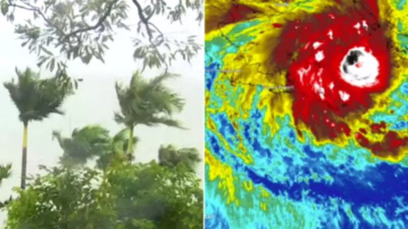
Millions of Australians are on high alert as Severe Tropical Cyclone Maila strengthens in the Solomon Sea, just off the country's northern coast. The system is expected to track towards Far North Queensland later this week, though its exact path remains uncertain. The Bureau of Meteorology has reported that Maila is currently producing sustained winds near 130 km/h, with gusts reaching up to 185 km/h, and is located approximately 590 km west of Honiara and 820 km east of Port Moresby.
Uncertain Path and Potential Impacts
Currently rated as a Category 3 cyclone, Maila has the potential to intensify further before fluctuating in strength in the coming days. Forecasters are unable to pinpoint a precise landfall zone due to shifting modelling, with steering influences currently weak and balanced, causing the system to move slowly in the Solomon Sea. Once these patterns change, the cyclone is expected to accelerate towards the coast.
Forecast modelling suggests that Maila could begin moving southwest by Thursday into the Coral Sea, with some scenarios indicating a coastal crossing north of Cooktown as early as Saturday, potentially as a Category 3 system. However, meteorologists warn that model guidance diverges significantly beyond midweek, meaning confidence in both timing and location remains low. Confidence in the track is expected to improve later in the week as steering patterns become clearer.

Comparison to Previous Cyclones and Broader Risks
If Maila makes landfall this weekend, it would be the second tropical cyclone to hit Queensland this year, raising fresh concerns for communities still recovering from Cyclone Narelle. Narelle, which caused widespread destruction across three states in March, made landfall near Coen as a Category 4 system after peaking at Category 5 offshore. Unlike Narelle, forecasters have yet to lock in a clear path for Maila, complicating preparation efforts.
Maila is expected to be a larger system, increasing the risk of more widespread impacts even if it does not make a direct hit. Dangerous conditions, including heavy rain, damaging winds, and coastal hazards, could extend far beyond the crossing point, particularly across already saturated catchments in the Far North. The Bureau of Meteorology has highlighted that longer-range scenarios include the system crossing Cape York Peninsula, weakening over land, and then re-intensifying over the Gulf of Carpentaria before moving into the Northern Territory early next week.
Current Status and Critical Next Steps
For now, Maila remains well offshore, but the situation is expected to evolve rapidly in the coming days. The next 48 to 72 hours are critical as forecasters work to narrow the cyclone's path and potential impact zones. Residents are urged to continue monitoring forecasts closely as the system develops and to stay informed through official weather updates. The growing size of Cyclone Maila in the Solomon Sea underscores the heightened risk of widespread rain and wind, making preparedness essential for vulnerable areas.