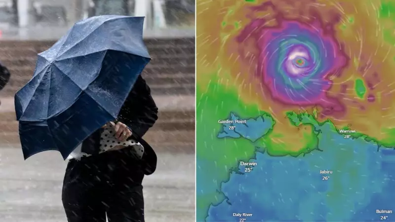
The first tropical cyclone of the 2025/26 season, named Fina, has officially developed to the north of Darwin, setting its sights on a potential coastal crossing for the Northern Territory as early as this Friday.
From Low Pressure to Cyclone Status
The Bureau of Meteorology confirmed the system's upgrade overnight, as wind gusts intensified to 100km/h, officially categorising it as a Category 1 cyclone. Senior meteorologist Miriam Bradbury reported that the storm is currently positioned approximately 300 kilometres north of Darwin and is moving at a slow pace of 9km/h.
Fina is forecast to continue tracking in an east-northeasterly direction and is expected to intensify into a Category 2 system by Wednesday night. In a significant shift, the cyclone is then predicted to make a U-turn, swinging back towards the southwest and heading for the Northern Territory coast.

Uncertain Path and Historical Significance
While current tropical cyclone track maps indicate Fina could swing towards Darwin, Ms. Bradbury emphasised that several scenarios are possible. "We may see a coastal crossing sometime over the weekend or into early next week," she stated. "However, there are a range of forecast scenarios... this includes the possibility that the system peters out before it reaches the coast, or that it moves further east or west and avoids a coastal crossing altogether."
This close monitoring underscores the uncertainty in the cyclone's trajectory. Fina's development is historically significant, as experts predict it could be the earliest cyclone to cross the Australian coast since records began around 1980/1981. The previous record was held by Tropical Cyclone Alessia, which crossed on November 27, 2013.
What to Expect in the Coming Days
For the immediate future, communities in the Northern Territory are not expected to feel Fina's direct impact within the next 48 hours. The weather experienced in the Top End, including showers and thunderstorms with a risk of heavy falls, is typical for the build-up season.
However, the situation is being watched closely. "Once we see the risk of gales developing along the Northern Territory coast in the next 48 hours, we will issue a tropical cyclone watch," Ms. Bradbury advised. This serves as an official warning flag for the imminent risk of cyclone impacts, which can include damaging winds, heavy rainfall, flooding, and coastal inundation.
On average, Australia's cyclone season sees about ten tropical cyclones, with three to four of those making landfall.