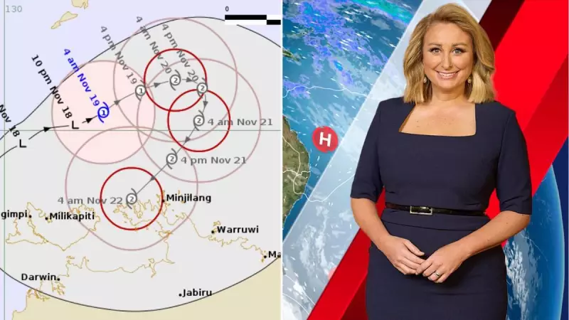
The first tropical cyclone of the Australian season, named Cyclone Fina, has officially formed to the north of Darwin, marking a significant start to the nation's cyclone period.
Understanding the Cyclone Beast
Cyclones like Fina typically progress through two distinct phases. The first involves the major build-up and potential coastal crossing, which can unleash catastrophic effects for communities in its direct path. The second phase deals with the system's 'leftovers'—the residual moisture and energy that linger long after the main event.
At their core, tropical cyclones are intense low-pressure systems. However, when they develop over ocean waters warmer than 26 degrees Celsius in a favourable atmospheric setting, they intensify into the powerful tropical systems we monitor closely. Their destructive potential is categorised on a scale from 1 (weakest) to 5 (strongest). It is also noteworthy that the terms tropical cyclone, typhoon, and hurricane all describe the same weather phenomenon, with the name varying by global region.

The Domino Effect of Cyclone Leftovers
Even if Cyclone Fina remains hundreds of kilometres away from you, its influence on your local weather could extend for the next couple of weeks. This is due to the leftover energy and moisture it injects into the broader weather pattern.
Once a cyclone makes landfall, it is cut off from its primary energy source—the warm ocean—and begins to weaken. However, such a vast and powerful system does not simply vanish. The remnants can persist within our weather systems, much like leftovers in a fridge, for a considerable time.
Whether Fina crosses the coast or continues to roam the oceans, it creates a massive ball of energy and moisture. This has the potential to be absorbed by other weather systems, such as troughs, lows, or cold fronts moving across southern or eastern Australia. When a regular weather system taps into these tropical leftovers, it can be supercharged, transforming into a system capable of producing significant rainfall.
A Season of Moisture and Rain Potential
Australia's atmosphere is already primed with moisture from several sources. The recent Negative Indian Ocean Dipole has been funneling moisture from the Indian Ocean, enhancing rainfall from weather systems during winter and spring.
Now, as we move through spring and into summer, we are beginning to see increased moisture from the Pacific Ocean due to a near or weak La Niña event. Combined with the significantly warmer-than-average sea surfaces surrounding the continent, this creates ample opportunity for onshore winds to feed moisture into weather systems.
The moisture from Cyclone Fina presents another substantial ingredient that could turn a standard weather system into one that delivers heavy and widespread rain. The final outcome, however, will depend on whether a connection is established between the cyclone's remnants and other incoming weather systems, as well as the specific tracks those systems take.