Perth's Golden Sunshine Set for Soggy Finish as Ex-Cyclone Narelle Looms
Perth's idyllic stretch of sunshine is poised to be disrupted by a wet and uncertain conclusion, with ex-tropical cyclone Narelle emerging as a potential game-changer later in the week. Meanwhile, Western Australia's northern regions have been issued a flood warning as heavy rain continues to fall.
Picture-Perfect Start to the Week
The week begins with ideal conditions: blue skies, light winds, and lingering summer warmth. Monday is expected to be warm, with temperatures peaking at 30°C. Tuesday follows a similar pattern, offering sunshine from wall to wall and the mercury again nudging 30°C before the seabreeze arrives.
On Wednesday and Thursday, temperatures are forecast to push into the low 30s with continued sunshine. However, this pleasant spell is not destined to last, as a powerful and unpredictable system is on the move to the north.

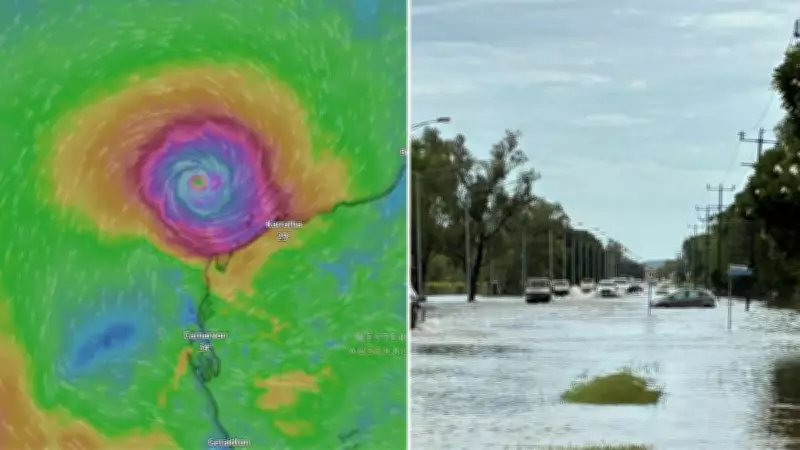
Ex-Cyclone Narelle's Threat Intensifies
Bureau of Meteorology forecaster Jessica Lingard reported that ex-tropical cyclone Narelle is already tracking towards Western Australia and beginning to influence weather conditions. "It is moving into the WA region during today, with the system forecast to travel across the northern parts of the Kimberley during today and overnight before popping out into waters west of the Kimberley tomorrow," she explained.
This is only the beginning. Ms Lingard warned that the system could reintensify once it moves back over open water. "Once it starts to move into the open waters north of the Pilbara, we are going to see it strengthening back up into tropical cyclone strength," she said. "We could see it reaching severe tropical cyclone strength for the third time as it moves north of the Pilbara, potentially during Wednesday."
Uncertain and Worrying Forecast
From there, the forecast becomes far less certain and far more concerning. "At this stage Narelle is expected to run parallel to the Pilbara coast on Wednesday and Thursday," Ms Lingard noted. "But there are a range of scenarios, including a more southward track off the WA coast towards the end of the week."
Some of these scenarios bring the system dangerously close to Perth. "There is a possibility the system will directly impact Perth," she acknowledged. "But models are showing a huge range of outcomes … some have it off the coast near Kalbarri, others have already pushed it through to south of Esperance."
The uncertainty is so significant that the bureau has drawn a large circle across northern WA on its seven-day tropical cyclone forecast map. "That large spread isn't the size of the system — it's a circle showing all the possible model outcomes," Ms Lingard clarified. "When we get five to seven days out, we really start to test the limits of tropical cyclone forecasting accuracy. They are fickle beasts."
Perth's Weekend Weather Flip
Despite the uncertainty, Perth is certain to experience rain by the weekend. "There is a wet forecast for the end of the week and the weekend," Ms Lingard confirmed. "How wet and how windy it becomes will depend on the path, movement and strength of the system."
This marks a dramatic shift in Perth's weather. By Friday, cloud will build, temperatures will ease into the mid-20s, and the first showers are likely, with up to 20mm of rainfall expected. Saturday will bring cooler, breezy conditions with up to 40mm of rain predicted. Sunday will be even cooler and possibly wetter, with temperatures topping out at 23°C.
Northern WA Already Feeling the Impact
In the north, conditions have already turned nasty, with a flood watch issued for the Kimberley region. Ms Lingard stated that the Kimberley is in the firing line, with heavy rain and deteriorating conditions expected as the system Narelle crosses from the Northern Territory into the WA coast.
"We're looking at 60 to 120mm for Kalumburu today, with isolated falls closer to 200mm," she said. "These tropical lows can absolutely pack a rainy punch." Conditions are expected to worsen throughout Monday before easing overnight, with Broome also set to feel the effects.

"Broome will likely see rainfall tomorrow and again on Wednesday, with totals depending on how the system tracks," Ms Lingard added. However, where Narelle goes next remains anyone's guess. "Some scenarios bring it down across the coast and into the south west, others keep it offshore," she said. "It's very much a watch-and-wait situation but people in western and southern WA should be keeping a close eye on it."