
The Bureau of Meteorology has issued a significant flood watch for a large area of North Queensland, warning residents that heavy, persistent rain is set to continue. The weather system, driven by a monsoon trough, poses a serious risk of river rises and potential flooding across multiple catchments.
Widespread Rainfall and Flooding Concerns
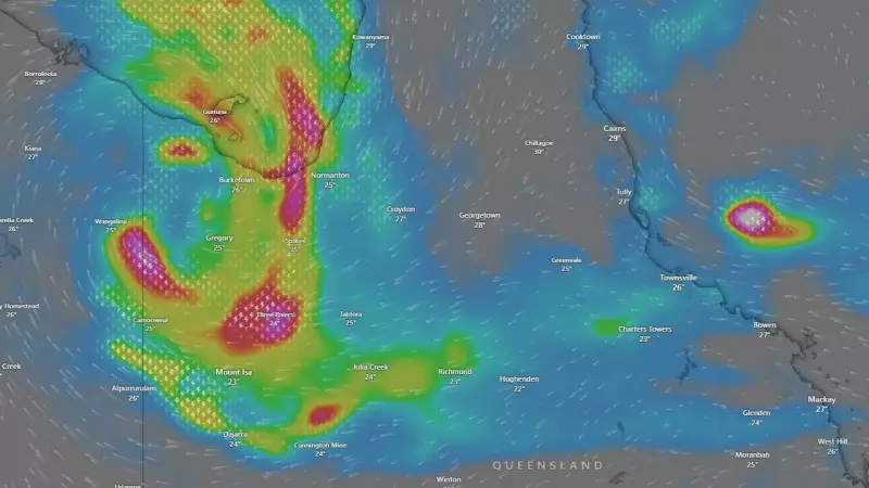
Meteorologist Shane Kennedy from the BOM stated that the monsoon trough is the primary driver of the unsettled weather. He confirmed that widespread rainfall totals of 50 to 150 millimetres are expected across the flood watch area over the next several days. Isolated areas, particularly near the coast and elevated terrain, could see significantly higher falls exceeding 200 millimetres.
The flood watch, current from late Tuesday afternoon, covers catchments including the Lower Herbert, Lower Burdekin, and parts of the Cape York Peninsula. Kennedy emphasised that the rain is not a one-day event but a prolonged period of wet weather. "We are expecting the rainfall to continue for the next few days, and that's really the main story here – it's not just going to be a one-off," he said.

Community Urged to Prepare and Stay Alert
Authorities are advising communities within the watch zone to take proactive steps. Residents should closely monitor official warnings from the BOM and their local disaster management groups. The key message is to prepare for possible isolation due to flooded roads and to have an emergency plan ready.
The situation is being closely monitored for any escalation to more severe flood warnings. The nature of the rainfall, being widespread and prolonged, increases the risk of riverine flooding as water accumulates in catchment areas. This differs from flash flooding caused by short, intense storms, but can be just as dangerous and disruptive.
Broader Weather Pattern and Regional Impact
The active monsoon trough is influencing weather across a broad section of northern Australia. While the immediate flood watch is focused on specific Queensland catchments, the unstable conditions extend further. The system is bringing increased humidity, cloud cover, and regular shower and storm activity to the region.
This weather event is a typical but potent feature of the North Queensland wet season. The BOM's warning underscores the importance for locals and visitors to stay updated with the latest forecasts. With the ground already saturated in some areas from recent rain, the capacity for water absorption is reduced, heightening the runoff and flood risk.
Residents are reminded to never drive, walk, or ride through floodwaters. The community should finalise their emergency kits, ensure they have essential supplies, and know where to find the latest official information as this significant rain event unfolds.


