Urgent Cyclone Warning Issued for WA's Kimberley Region
An urgent weather alert has been activated for residents across Western Australia's northern regions as a category two cyclone continues to intensify off the coastline. The Bureau of Meteorology has implemented a comprehensive watch zone stretching from Mitchell Plateau to Bidyadanga due to an approaching tropical storm system.
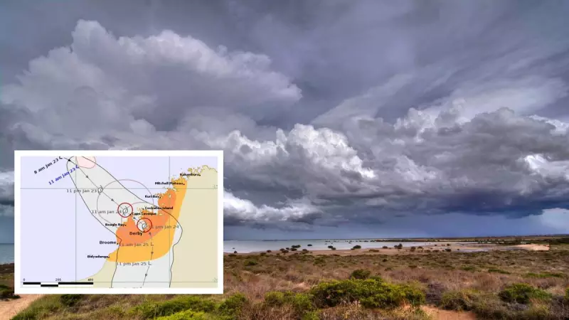
Warning Zones and Landfall Predictions
Residents between the popular holiday destination of Broome and Kuri Bay have been placed under an official cyclone warning zone. Weather experts anticipate the system will make landfall on Saturday somewhere between these two locations, bringing potentially destructive conditions to the area.
The tropical low is currently positioned northwest of the Kimberley coast, with meteorologists expecting continued intensification throughout Friday as it moves in a southeasterly direction. As of 11am Friday, the system has already achieved wind speeds exceeding 65km/hr with gusts reaching 95km/hr.

Projected Path and Impact Areas
Maps from the Bureau of Meteorology indicate the cyclone will approach the town of Derby around 11pm on Saturday. Multiple warnings have been issued to prepare residents for what could be a weekend of severe weather conditions across the region.
Coastal communities between Cockatoo Island and Beagle Bay have been alerted to expect destructive wind gusts potentially reaching 130km/hr on Saturday. Damaging winds up to 120km/hr are also forecast between Kuri Bay and Beagle Bay from Friday evening onward.
Additional Weather Threats
The gale-force winds may extend east toward Derby and south toward Broome on Saturday morning as the system makes landfall. The northwest Kimberley district, including both coastal and inland areas, faces warnings of heavy rainfall and potential flash flooding beginning Friday night.
Residents within King Sound have been alerted to the possibility of dangerous storm tides resulting from the cyclone, with rising tides increasing risks of damaging waves and dangerous flooding. Those in Cape Leveque and Cockatoo Island have also received warnings about rising tides, with low-lying coastal areas particularly vulnerable to minor flooding.
Emergency Preparedness Recommendations
The Department of Fire and Emergency Services continues to monitor the developing situation closely. Residents in affected areas are strongly urged to check for regular updates and prepare thoroughly for potentially dangerous weather conditions.
Emergency Preparedness Checklist:
- Prepare your home both inside and out by securing boats, caravans, trailers, garden sheds, outdoor furniture, rainwater tanks, LPG bottles, and any loose materials
- Ensure your emergency kit is complete and that all family members understand emergency procedures
- Create an emergency plan if you don't already have one, using the Emergency WA website or mobile application
- Your emergency kit should include sufficient canned food and water for five to seven days, a comprehensive first aid kit, necessary medications, cash reserves, and a battery-operated radio with spare batteries
- Familiarize yourself with cyclone warning levels and the specific actions required for each level
- Regularly monitor the Emergency WA website for the latest updates and information
Travellers, visitors, and tourists currently in the warning area are strongly advised to leave immediately to ensure their safety. For comprehensive information on cyclone preparedness, residents should consult official emergency resources.