Far North Queensland on High Alert as Tropical Cyclone Narelle Approaches
Residents across Far North Queensland are being urged to prepare for what could be one of the most powerful tropical cyclones to strike the region in over a decade. Evacuations are already in progress as authorities issue urgent warnings for communities to brace for the impending impact of Tropical Cyclone Narelle.
Premier Issues Dire Warning as Storm Intensifies
Premier David Crisafulli has emphasized the gravity of the situation, stating during a news conference in Brisbane on Wednesday that the window for action is rapidly closing. "It's a serious situation and the window to act is obviously closing," Crisafulli said. "We're asking people to take those final bits of precaution and do the final little bits of work." He highlighted that resources, including 49 police officers, 74 fire and rescue crews, and 20 paramedics, have been deployed to remote northern communities to assist with preparations and potential emergencies.
Evacuations and Preparations Underway
Evacuation efforts are already active, with four people relocated from Port Stewart to Cook Town, and Lizard Island largely evacuated except for a few resort staff. Special considerations are being made for vulnerable residents, such as those requiring medications like dialysis and pregnant women, who have been offered opportunities to relocate ahead of the cyclone's landfall.

Forecast Details and Potential Impacts
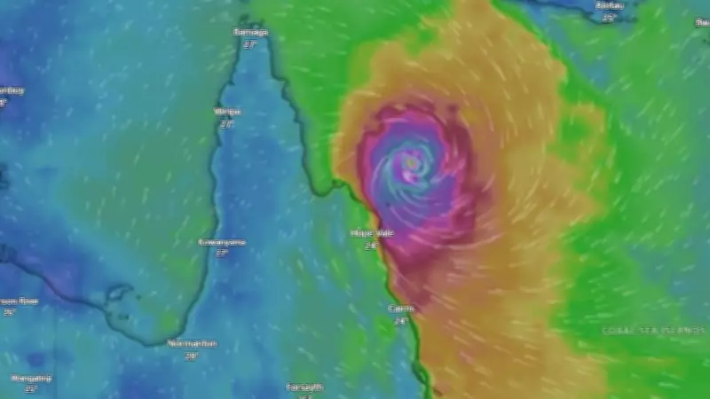
Senior meteorologist Jonathan How provided an update, noting that Tropical Cyclone Narelle was named on Tuesday afternoon in the Coral Sea, marking the 10th named cyclone in the Australian region this season. Currently a category two system located about 1,100km northeast of Cairns, it is expected to strengthen significantly as it approaches the coast. Forecasters predict it will make landfall near Cape Melville on Friday morning as a severe category four or five system, with wind gusts exceeding 200km/h and up to 450mm of rainfall in some areas.
- Wind Speeds: Up to 200km/h, potentially causing widespread damage.
- Rainfall: Approximately 450mm predicted, leading to flooding risks.
- Affected Areas: Communities between Lockhart River and Port Douglas, including inland regions like Cowen, Cooktown, and Woodjill Woodjill.
Historical Context and Ongoing Threats
The last category four storm hit northern Queensland in 2017, with the most recent category five occurring in 2015, underscoring the rarity and severity of this event. After crossing the coast, Narelle is expected to maintain cyclone intensity as it moves over Cape York Peninsula and into the Gulf of Carpentaria, where it could strengthen again before a potential second landfall over the eastern Top End of the Northern Territory. This prolonged activity may bring heavy rainfall and damaging winds to additional areas over the weekend and into early next week.
Residents are advised to stay informed through official channels and take all necessary precautions to ensure safety during this critical period.