Cyclone Narelle Strengthens as Severe Weather Sweeps Across Australia
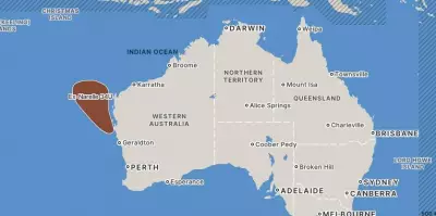
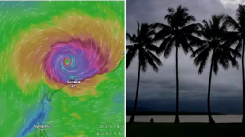
Severe tropical cyclone Narelle has re-intensified, posing a significant threat to Western Australia as it approaches the mainland. The storm is forecast to cross the WA coast on Friday morning, bringing destructive winds and heavy rainfall that could lead to widespread disruptions and damage.
National Parks Closed and Evacuations Underway
In response to the escalating threat, authorities have initiated evacuations and closures in vulnerable areas. The Parks and Wildlife Service has shut down several locations, including Cape Range National Park, Nyinggulara National Park, and Nyinggulu Coastal Reserves, effective from 4.30pm on Wednesday. Campers and holidaymakers have been instructed to pack up and move to safer zones, with these sites to be reassessed after the weather event passes.
"All day use sites and campgrounds in the parks are closed," the Parks and Wildlife Service stated, emphasizing the urgency of the situation.

Cyclone Narelle Expected to Further Intensify
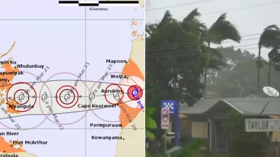
The Bureau of Meteorology (BOM) reports that cyclone Narelle is currently a category 3 tropical cyclone, with wind gusts reaching up to 220km/h. It is expected to continue strengthening on Thursday, potentially reaching category 4 status by Friday as it turns southward, likely passing close to the North West Cape.
Warning zones are in place from Pardoo Roadhouse to Carnarvon, with a watch zone extending south to Jurien Bay. BOM notes that Narelle is larger than usual, with gales already affecting the Pilbara coast despite the cyclone's northern location. Severe impacts are anticipated for the west Pilbara and Gascoyne coasts, potentially extending to Denham by Friday.
Severe Weather Warning Issued for NSW and ACT
Meanwhile, a severe weather warning has been issued for New South Wales and the Australian Capital Territory ahead of damaging winds and storms forecast for Friday morning. Forecasters warn of a "vigorous coastal low" developing offshore of the southern NSW coast, which could bring damaging southerly winds to parts of the southeast, including the ACT and Sydney coast.
Damaging wind gusts of around 100km/h are predicted to hit the Snowy Mountains and South Coast from Friday morning, spreading northward into other warning areas. Wind gusts along the coastal fringe of the South Coast and Illawarra may reach 110km/h during Friday afternoon, according to BOM. Conditions are expected to ease later on Friday and into early Saturday as the low moves further offshore.
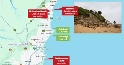
Areas forecast to be affected include Sydney's coast, Wollongong, Nowra, Batemans Bay, Eden, Cooma, and Bega.
Flight Cancellations and Travel Disruptions
In anticipation of the severe weather, Port Hedland International Airport has cancelled all Qantas and Virgin flights scheduled for Wednesday night and Thursday morning. Travelers are advised to check directly with their airlines for updates on bookings and re-booking options.
"If you were due to travel tomorrow morning via Qantas (or Virgin Australia), please check directly with Qantas (or Virgin Australia), for the latest updates regarding your booking, including re-booking options," a spokesperson said on Wednesday.
As cyclone Narelle and the coastal low system continue to develop, residents in affected regions are urged to stay informed through official channels and take necessary precautions to ensure safety. The situation remains fluid, with further updates expected as the weather events unfold.