Cyclone Narelle Makes Historic Landfall in Far North Queensland
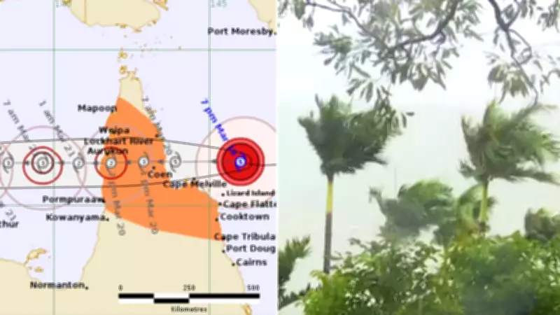
Tropical Cyclone Narelle has struck the far north Queensland coast this morning as a category five system, marking the first weather event of this intensity in more than a century. The powerful cyclone headed directly for the small town of Coen, which has a population of around 400 people, making landfall at approximately 7am on Friday with wind gusts exceeding 250km/h at the centre of the system.
Unprecedented Weather Event and Historical Context
If it maintains its current strength, Cyclone Narelle is expected to be the first category five system to make landfall in the region in over 100 years. The last comparable event was in 1899, when Australia’s deadliest cyclone hit north Queensland, resulting in the tragic deaths of 300 pearl divers. The Bureau of Meteorology forecasts that Narelle will land between Lockhart River and Cape Melville, continuing to move over the Cape York peninsula while weakening from a category five to a two.
Severe Impacts and Warnings for Queensland
Heavy rainfall, which may cause flash flooding, is likely between Cape Melville and Cape Tribulation, extending north and inland to areas west of Coen on Friday. Locally intense rainfall is also forecast for the area around Lockhart River, Cape Flattery, Pormpuraaw, and Weipa. Authorities are particularly concerned about the storm surge, with high tides and large waves posing a risk of flooding in low-lying coastal areas between Coen and Cape Tribulation.

There is a small risk that tides may approach the highest tide of the year during Friday, according to the Bureau of Meteorology. Premier David Crisafulli warned residents, stating, “I can’t sugarcoat this, the damage will be widespread with a system of that size.” Schools closed on Thursday afternoon, and tourist locations, such as Lizard Island, have taken precautions, with 10 staff remaining to ride out the storm while others were flown to Cairns.
Preparations and Community Response
The Australian Army is on standby as Cyclone Narelle bears down on the region. In Cooktown, boaties prepared to spend the night on board vessels to ensure everything was tied down. The wider feeling in town was mixed, with some locals expressing resilience, as one resident noted, “We’ve been here too long and seen too much.” However, authorities have urged all residents to take the situation seriously, emphasizing that this is a rare and large event.
Forecast for the Northern Territory
As Cyclone Narelle continues its path, it is forecast to strengthen again to a category three before impacting the eastern Northern Territory from late Saturday. Gales are not expected in coastal areas of the Northern Territory in the next 24 hours but will develop between Port McArthur and Nhulunbuy on Saturday afternoon as Narelle edges closer. Very destructive winds are forecast for Saturday night, with heavy rainfall that may lead to flash flooding possible for coastal areas over the eastern Top End from late Saturday, accompanied by large waves that bring further risk of inundation.
Authorities have warned that extensive damage is expected in the wake of the cyclone, and while many were urged to evacuate earlier, it is now too late for some areas. Residents are advised to stay informed and follow all safety instructions as the situation evolves.