Cyclone Narelle Escalates to Category Five, Posing Multi-State Threat
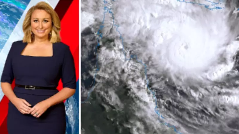
Cyclone Narelle has developed rapidly off the far northeastern coast of Queensland, intensifying to a Category Five storm by Thursday afternoon. This powerful system is moving swiftly towards Australia, with forecasts indicating it will affect three states and territories over an extended period before dissipating.
Rapid Intensification and Path of Destruction
Initially reaching Category Four by Thursday morning, Cyclone Narelle quickly escalated to the highest level on the scale, Category Five. These tropical storms, known as typhoons or hurricanes in other regions, deliver a dangerous combination of flooding rain, significant winds, and storm surge as they approach coastlines. Wind gusts in excess of 250km/h are typical for Category Five cyclones, posing severe risks to affected areas.
When cyclones like Narelle target Australia's east coast, the most severe conditions typically occur directly underneath and just south of the storm's path. This is due to the clockwise rotation of winds around the low-pressure system, which concentrates the worst impacts in these zones. In contrast, areas to the north often experience relatively benign weather.

Forecasted Landfalls and Weakening Patterns
Cyclone Narelle is projected to cross the coast well north of Cooktown on Friday morning, primarily impacting the Cape York Peninsula rather than densely populated areas like Cairns. Upon landfall, the cyclone will lose its primary energy source, as these systems require ocean waters of 26°C or higher to sustain intensity. The waters east of Cape York are approximately 28°C, while the Gulf of Carpentaria to the west is around 30°C, but the intervening landmass will cause rapid weakening.
However, the narrow width of the Cape York Peninsula means Narelle may not fully downgrade to a tropical low before reaching the Gulf of Carpentaria. Once over these warm waters, it is expected to rapidly intensify again, continuing its westward trajectory without slowing down.
Multi-State Impact and Continued Risks
The cyclone is likely to make a second landfall in the Northern Territory by Saturday night or early Sunday morning, again in a sparsely populated region. The wider landmass of the Top End should lead to a full downgrade as Narelle passes through, but upon reaching the ocean on the other side, rapid redevelopment could occur. This resurgence introduces risks for Western Australia, with Narelle potentially grazing the Kimberley coast early next week and intensifying over warm tropical waters.
This prolonged event underscores the cyclone's persistent threat, with flooding rain, destructive winds, and storm surge expected across Queensland, the Northern Territory, and Western Australia. Residents in these areas are advised to stay informed through official weather updates and prepare for potential impacts over the coming days.