Residents across Western Australia's Kimberley region are being urged to prepare for severe weather as Tropical Cyclone Hayley strengthens off the coast. The system poses a significant threat of damaging winds, intense rainfall, and potential flooding.
Cyclone Hayley's Path and Intensity
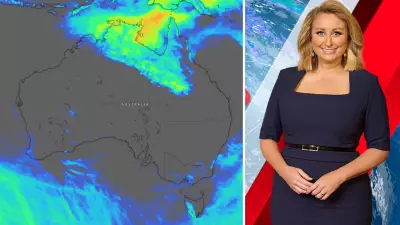
Tropical Cyclone Hayley formed approximately 535 kilometres north-west of Broome overnight and has been classified as a category one system. However, the Bureau of Meteorology forecasts it will intensify to a category two cyclone by Monday afternoon. The system is tracking southwards and is expected to begin affecting the Kimberley coast by New Year's Eve or New Year's Day.
Current projections indicate the cyclone will bring wind gusts of up to 120 kilometres per hour, with the potential for damaging winds reaching 140 km/h. The BoM has established a watch zone stretching from Broome to Cockatoo Island in the Buccaneer Archipelago, which also includes the town of Derby.

Official Warnings and Community Advice
Meteorologist Jonathan How stated that communities in the danger zone need to remain on high alert. "As Tropical Cyclone Hayley nears the Kimberley coast, we can expect to see showers and thunderstorms increasing across that part of WA," Mr How said. "And as the tropical cyclone makes landfall, at this stage on New Year's Eve during the morning, we can expect to see heavy rain, possibly damaging winds."
Senior forecaster Luke Huntington noted the system's strength at landfall could vary. "It just depends what strength the system is while it is offshore. A stronger system is going to take a longer time to weaken. If it is a weaker system, it's going to weaken more rapidly," he explained.
The Bureau of Meteorology has issued specific advice for residents in the watch zone:
- Park vehicles undercover and away from trees.
- Secure homes by closing doors and windows.
- Keep essential medications, like asthma inhalers, close by.
- Charge mobile phones and power banks in preparation for possible power outages.
- Avoid driving unless absolutely necessary.
This warning comes just years after Broome was impacted by Tropical Cyclone Kelvin in February 2018, reminding locals of the serious threat these systems pose.
Monsoonal Rains and Flooding Threaten Queensland
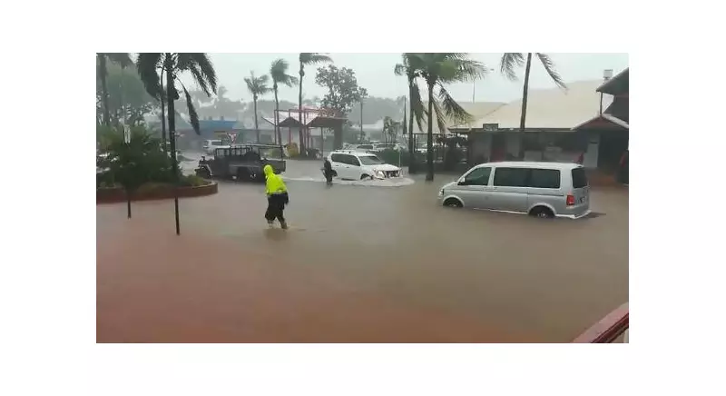
Meanwhile, a separate severe weather event is unfolding on the opposite side of the country. Heavy monsoon rain is expected to lash parts of Queensland this week, with fears of up to 700 millimetres of rain in some areas. This is likely to cause widespread flooding.
Rainfall totals are predicted to climb "very quickly" across the state, particularly in the north. Affected areas throughout the week include Mt Isa, Normanton, Weipa, Cairns, and Townsville. On Wednesday, much of western Queensland could see in excess of 300mm of rain. On the north-east tropical coast, four-day totals near Cairns may exceed 700mm.
Jonathan How warned of the compounding dangers. 'Heavy rain leading to flash and riverine flooding will pose a risk to property and life so make sure you follow all the advice from your local authorities,' he said. 'Additionally, heavy rainfall will lead to road closures and community isolation, and this could last for quite some period of time, especially for outback and more remote communities.'
The severe weather is also expected to impact agriculture, with low temperatures and prolonged floodwaters posing a risk to cattle and livestock. In the Top End, a minor flood warning is active for the McArthur River, and a flood watch is in place for the Barkly and Carpentaria catchments due to continued heavy rainfall.