Communities across the Northern Territory's Top End are on high alert as Tropical Cyclone Fina gains strength off the coast, with forecasts indicating a likely land crossing in the coming days. The system intensified overnight, evolving into a Category 2 cyclone and prompting official warnings for residents to prepare immediately.
Storm Track and Expected Impact
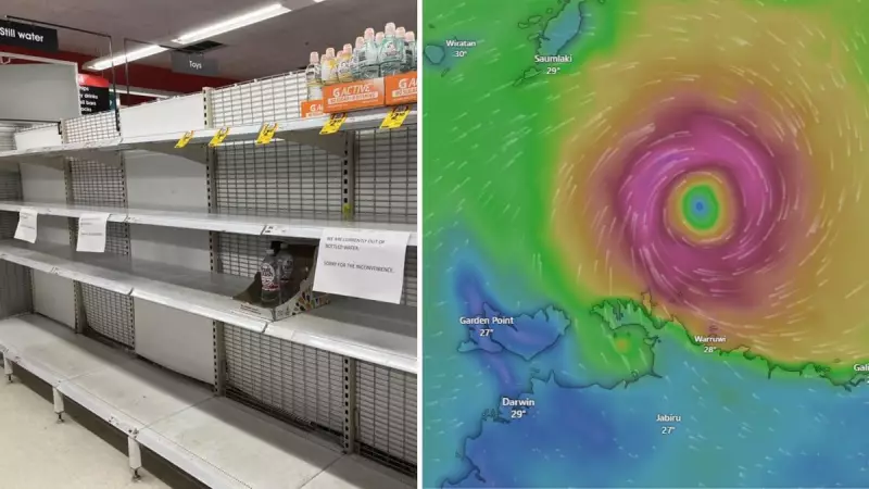
The Bureau of Meteorology has confirmed that Tropical Cyclone Fina strengthened into a category 2 system overnight, with wind gusts now reaching 130km/h. The system is picking up momentum and is expected to begin turning south towards the Top End on Thursday.
Senior meteorologist Angus Hines provided a detailed timeline, stating, "At this stage it looks likely that we see a coastal crossing in the northern coastline of the top end around the Cobourg Marine Park area, and this looks likely to occur through the very early hours of Saturday morning, around about 3am or so local time."

There remains a significant chance that Fina could strengthen further to a severe category 3 tropical cyclone before it makes landfall. As the system continues on a southwesterly track, Mr Hines noted that more coastal crossings are possible, including over the Tiwi Islands.
Warning Zones and Darwin's Weekend Forecast
The Bureau of Meteorology has issued specific zones for the cyclone's path. A tropical cyclone "warning zone" is currently in effect, which includes Cape Don to Maningrida, incorporating the Cobourg Peninsula, Minjilang, and Warruwi.
A separate "watch zone" has been issued for the Tiwi Islands and Darwin, extending east to Gunbalanya. For Darwin residents, the main impacts are still a couple of days away, but conditions are expected to deteriorate significantly over the weekend.
"For Darwin, the main impacts are still a couple of days away, but the strong wind and potential for heavy rainfall really does ramp up over the weekend," Hines said. "Certainly we see the risk there for heavy rainfall, thunderstorms and flash flooding, particularly during Saturday and Sunday."
From around midday Saturday, Darwin could see extremely strong winds potent enough to cause damage to property and trees. The community has been warned of potential power outages and very rough conditions on all coastal waters.
Community and Government Response
The emergency response is already mobilising, with Federal Minister for Emergency Management Kristy McBain receiving a briefing from National Emergency Management Agency (NEMA) coordinator general Brendan Moon in Canberra on Wednesday.
"We've already deployed NEMA officials to the Northern Territory, and we're working really closely with the Northern Territory government as this tropical cyclone develops," Minister McBain stated. "It's really important now that communities prepare and make sure they are taking the appropriate steps and listening to the emergency advice from the Northern Territory government."
On the ground, Darwin residents are heeding the warnings. Local reports indicate that supermarket shelves have been emptied of bottled water, some canned foods, and bread as shoppers urgently stock up on essential supplies.
NT Emergency Services have issued clear guidance for preparation, advising residents to:
- Create an emergency kit and an emergency plan
- Clear gardens of dead trees or branches
- Secure all loose items around their properties
This weather event brings back memories of the last major cyclone to impact Darwin, when Category 2 system Marcus cut power to nearly 29,000 properties in March 2018. With Fina potentially reaching a similar or greater intensity, authorities are emphasising that preparation in the coming hours is critical for community safety.