
The Bureau of Meteorology is closely monitoring a developing weather system in the Coral Sea that has the potential to form into a tropical cyclone later this week. The system, currently classified as a tropical low, is expected to intensify as it moves slowly in a general southerly direction.
Bureau Issues Official Watch for Coral Sea System
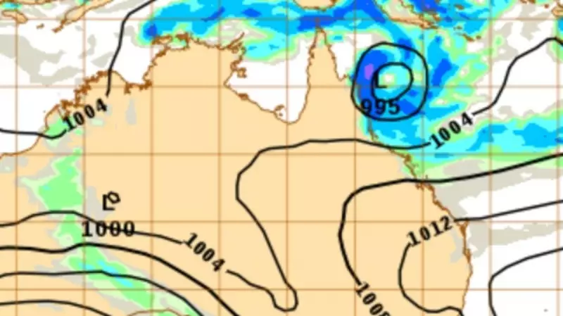
As of Monday, the Bureau confirmed the presence of the tropical low, located approximately 1000 kilometres east of Cairns. Meteorologists are tracking its movement and development, noting that environmental conditions are becoming more favourable for cyclogenesis. The system is forecast to track slowly southwards over the coming days, with its future path and intensity remaining uncertain at this early stage.
"There is a risk that the system may develop into a tropical cyclone from Thursday," a Bureau spokesperson stated. The official cyclone watch highlights the need for communities along the Queensland coast, particularly north of Mackay, to stay informed. The Bureau has emphasised that the situation is evolving and that regular updates will be provided.

Uncertain Path and Potential Impacts for Queensland
While the possibility of cyclone formation exists, it is still too early to predict with confidence whether the system will cross the Queensland coast or remain offshore. Current modelling suggests a range of scenarios, from the low intensifying into a named cyclone and moving towards the coast, to it remaining a weaker system that stays out to sea.
Regardless of its final classification, the system is expected to generate significant weather. It is likely to bring increased shower and thunderstorm activity to coastal and island communities later in the week. The Bureau has warned that heavy rainfall, damaging winds, and dangerous surf conditions could develop, depending on the system's ultimate track and strength.
Residents Urged to Prepare and Stay Informed
Authorities are advising residents across North Queensland to use this time to ensure their cyclone preparedness plans are in order. This includes checking emergency kits, securing loose items around properties, and reviewing official evacuation routes if necessary. The key message from emergency services is not to panic but to prepare and to rely on official sources for information.
The Bureau of Meteorology will provide its next detailed update on the system's status and forecast track on Tuesday. Residents are encouraged to monitor the Bureau's official website and warnings, listen to local radio updates, and follow advice from the Queensland Fire and Emergency Services (QFES). The coming days will be critical in determining the level of threat posed by this Coral Sea weather event to the Australian mainland.


