Australia's Extreme Weather Chaos: Snow, Hail, Dust Storms and Cyclones Hit Multiple States
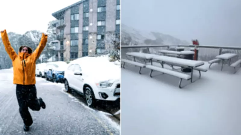
Australia has been struck by a chaotic and dangerous mix of extreme weather events, with snow, hail, dust storms, and powerful winds sweeping across multiple states, causing widespread disruptions and damage. Residents in parts of New South Wales and Victoria awoke to the first snowfall of the year, with up to 8 centimetres recorded in alpine regions as temperatures plummeted below zero degrees Celsius.
Snowfall in Early Autumn Surprises Alpine Regions
Snow was reported across the Australian Alps, with major ski resorts including Falls Creek, Hotham, Perisher, and Thredbo all receiving their first snowfall of the season, despite it being only early autumn. "We're thrilled to have received a very special delivery just before Easter, our first snowfall for 2026!" said Falls Creek manager Betony Pitcher. "The team up here at Falls Creek could not be more excited as we put the finishing touches into our summer projects." Snow was also observed as far north as Orange in the Central Tablelands, highlighting the unusual weather patterns.
Severe Weather Warnings and Impacts Across NSW
The Bureau of Meteorology issued multiple warnings, including blizzard conditions expected in alpine areas on Friday, easing later into early Saturday. However, harsh conditions are forecast to persist across the Illawarra, South Coast, Central Tablelands, Southern Tablelands, South West Slopes, Snowy Mountains, and the ACT, with cold temperatures, heavy rain, and strong southwesterly winds. The bureau also warned sheep graziers of potential livestock losses due to the severe conditions.

Damaging surf is developing along central and southern coasts, driven by a vigorous coastal low off southern NSW on Friday, generating gale to storm-force southerly winds and very large, powerful seas. Wind warnings are in place for southeastern NSW, with gusts along the South Coast and Illawarra forecast to reach up to 110 kilometres per hour, and potentially 120 kilometres per hour in exposed areas. Further north, storm-force conditions are forecast for the Hunter region.
Storm Damage and Cleanup Efforts in NSW
New South Wales is cleaning up after wild storms battered parts of the state overnight, toppling trees and blanketing suburbs in hail. The NSW State Emergency Service responded to more than 400 call-outs, while over 5,000 homes in Sydney were left without power on Friday morning. In Sydney's southwest, photos from Menangle Park show hailstones piled into large mounds after the storm. In western NSW, Dubbo was hit by a powerful dust storm, with winds up to 115 kilometres per hour toppling a crane in the central business district on Thursday afternoon, and more than 15,000 households across the region lost power, including traffic lights in Dubbo's CBD.
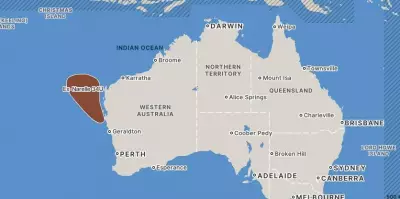
Cyclone Narelle Batters Western Australia
Meanwhile, Severe Tropical Cyclone Narelle continues to batter Western Australia, having strengthened to a category 4 cyclone with sustained winds near the centre reaching 175 kilometres per hour and gusts up to 250 kilometres per hour. Communities from Mardie to Jurien Bay, including Onslow, Exmouth, Coral Bay, Carnarvon, Denham, and Geraldton, have been impacted, with warnings extending inland. The Bureau of Meteorology stated that Narelle has begun weakening and is expected to continue to weaken as it tracks south-southeast into Saturday.
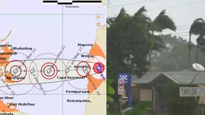
Flood Warnings in Queensland and Fire Risks
In Queensland, major flood warnings are in effect, including along the Thomson River and Cooper Creek, adding to the nationwide weather chaos. Additionally, strong winds are fuelling total fire bans and high to extreme fire risks in the New England and Northern Slopes regions of NSW, complicating emergency responses. Gale warnings have also been issued for Sydney's enclosed waters and the Macquarie Coast, while strong wind warnings extend to the Coffs Coast, underscoring the widespread nature of this extreme weather event.