An Australian expedition cruise operator is transforming how we see the polar regions, not through traditional light but through the vivid colours of heat. Aurora Expeditions has partnered with the Thermal Imaging of Polar Ice (TIPI) project to deploy specialised thermal imaging technology across its Arctic voyages, creating striking visual data about environmental change.
Seeing Ice Through the Lens of Temperature
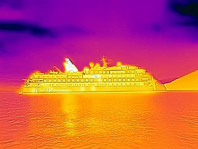
The innovative program uses advanced thermal cameras that detect minute surface temperature differences across ice formations and glaciers. Rather than capturing images in conventional monochrome or colour photography, this technology translates temperature variations into a spectrum of colours – revealing reds, oranges, and yellows where warmer areas exist, and cooler blues and purples where temperatures drop.
This approach allows researchers and expedition participants to visualise ice dynamics through heat signatures rather than reflected light, providing entirely new insights into polar environments. The resulting images are not only visually captivating but serve as powerful educational tools for understanding complex climate processes.

Citizen Science at the Frontier of Climate Research
Led by TIPI founder Joe Muise, the project represents a significant advancement in polar citizen science initiatives. Aurora Expeditions has become the first expedition operator to implement thermal imaging technology at scale within a dedicated citizen science program, making the system fully operational across their fleet.
An Aurora Expeditions spokesperson explains the program's significance: "The project offers expeditioners a powerful new way to visualise temperature, melt and change in polar environments, revealing patterns not visible to the human eye."
Throughout each voyage, Aurora's expedition team and citizen science coordinators actively involve clients in the data collection process. Passengers participate in capturing thermal imagery that contributes to a growing database of polar observations.
Building a Foundation for Long-Term Climate Study
The partnership has focused on developing scientific methodologies that produce robust, repeatable, and valuable data capable of supporting long-term climate studies. By piloting and refining these techniques in real expedition conditions, researchers are establishing protocols that could yield important longitudinal datasets.
Joe Muise emphasises the project's potential: "Thermal imaging lets us visualise information that we normally can't — allowing us to track temperature, melt, and subtle changes in ice. By piloting and strengthening the methodology in real expedition conditions, we're laying the groundwork for what could become a valuable longitudinal dataset."
The thermal imaging initiative represents a convergence of tourism, technology, and science – offering expedition participants not just a journey to remote locations, but an opportunity to contribute meaningfully to our understanding of polar environments and climate change impacts.