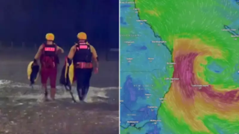
The cleanup is now underway after devastating floods and heavy rainfall hammered parts of southeast Queensland and northern New South Wales. While forecasters predict additional rain in the coming days, they believe the worst of the weather has passed.
Torrential rain causes widespread chaos
The torrential downpour was caused by a slow-moving rain band that crept across the east coast before moving offshore into the ocean late on Tuesday. However, the deluge led to more than a dozen rescues across the region. The highest recorded rainfall total was 276 millimetres at Springbrook National Park.
Multiple locations across the southeast and northern rivers areas received more than 200 millimetres, causing rivers to swell and burst their banks. Flash-flooding cut off several major roads on the Gold Coast as the State Emergency Service received more than 100 calls for help.

Rescues and tragic incidents
People were pulled from cars stuck in floodwaters, and swift water rescue teams ferried individuals trapped by water blocking roads. A school group of 48 Year 12 students and teachers from North Lakes State College in Brisbane was also caught in the downpour. The group became trapped as floodwaters rose while they were at a camp at Mount Barney on the Scenic Rim. Water rescue and SES teams were called out about 5pm on Monday after the group was unable to cross a flooded area to return to their camp. All were safely rescued and no one was hurt.
Two hikers were also caught on Mount Barney: Jackson Richards, 18, and his friend, 20, spent two nights trapped in freezing and dangerous conditions. The pair were winched to safety on Tuesday and flown to Brisbane’s QEII Hospital for observation.
During the heavy rain on Monday afternoon, a 28-year-old woman died on the Pacific Motorway at Loganholme, south of Brisbane, after pulling over following a minor rear-end crash. Two vehicles had stopped in the northbound lanes to exchange details before the woman was hit by a dual-cab utility as she walked back to her car, police said. She suffered catastrophic head injuries and could not be revived. The ute driver is assisting police.
Weather records and outlook
More than a month’s worth of rain fell in just 12 hours in some places, while others, including the Gold Coast Seaway, observed their highest daily May rainfall since 2003, according to the Bureau of Meteorology. While the worst of the rain is now over, forecasters say more rain is on the way for later in the week. However, this rain is not expected to impact already swollen rivers and creeks.
New low-pressure system forming
A low-pressure system is now forecast to develop in the Tasman Sea, with warnings of hazardous surf. “A low pressure area is developing in the Tasman Sea on Wednesday and will drive southerly winds and large powerful waves along the NSW coastline, extending to the southern Queensland coast from Friday,” BOM said. “Hazardous surf conditions are possible for much of the coastline from midweek as large powerful waves develop from southerly directions.”
Wave heights are expected to reach 3 to 4 metres on Wednesday, increasing to 4 to 5 metres from late Thursday until Saturday. “A hazardous surf warning may be issued for rock fishers, boaters and swimmers at risk from large swells and waves,” BOM said. “A coastal hazards warning for damaging surf may be issued as waves increase later in the week for communities vulnerable to large waves that may cause coastal erosion or damage to coastal infrastructure.”
A cool change is expected to follow, with temperatures forecast to sit 2 to 6 degrees Celsius below average across much of central and eastern Australia for the rest of the week before edging back towards normal by the weekend.

Capital city weather forecasts
Brisbane
- Wednesday: Sunny, max 24
- Thursday: Sunny, 13-24
- Friday: Partly cloudy, 14-23
- Saturday: Partly cloudy, 16-25
- Sunday: Partly cloudy, 17-24
- Monday: Partly cloudy, 16-25
- Tuesday: Possible shower, 15-23
Sydney
- Wednesday: Mostly sunny, max 20
- Thursday: Shower or two, 12-20
- Friday: Showers easing, 14-21
- Saturday: Showers, 16-21
- Sunday: Shower or two, 15-23
- Monday: Shower or two, 13-21
- Tuesday: Shower or two, 11-18
Melbourne
- Wednesday: Shower or two, max 17
- Thursday: Cloudy, 9-16
- Friday: Partly cloudy, 6-17
- Saturday: Partly cloudy, 7-19
- Sunday: Shower or two, 11-18
- Monday: Showers, 8-14
- Tuesday: Shower or two, 7-15
Adelaide
- Wednesday: Possible shower, max 20
- Thursday: Partly cloudy, 10-20
- Friday: Becoming cloudy, 11-20
- Saturday: Partly cloudy, 13-21
- Sunday: Shower or two, 11-18
- Monday: Shower or two, 10-17
- Tuesday: Possible shower, 7-17
Perth
- Wednesday: Mostly sunny, max 25
- Thursday: Showers increasing, 10-23
- Friday: Mostly sunny, 8-19
- Saturday: Sunny, 5-19
- Sunday: Mostly sunny, 6-22
- Monday: Sunny, 9-24
- Tuesday: Shower or two, 10-24
Hobart
- Wednesday: Cloudy, max 15
- Thursday: Partly cloudy, 7-17
- Friday: Partly cloudy, 8-18
- Saturday: Partly cloudy, 7-17
- Sunday: Possible shower, 9-18
- Monday: Shower or two, 8-14
- Tuesday: Shower or two, 7-13
Darwin
- Wednesday: Sunny, max 33
- Thursday: Sunny, 23-32
- Friday: Sunny, 23-32
- Saturday: Mostly sunny, 23-32
- Sunday: Sunny, 24-33
- Monday: Mostly sunny, 23-33
- Tuesday: Sunny, 21-31
Canberra
- Wednesday: Partly cloudy, max 16
- Thursday: Sunny, 2-17
- Friday: Morning frost. Mostly sunny, 1-18
- Saturday: Cloudy, 5-18
- Sunday: Shower or two, 7-18
- Monday: Shower or two, 6-15
- Tuesday: Shower or two, 4-13