Queensland and Northern Territory Hit by Severe Flooding Amid Heavy Rainfall
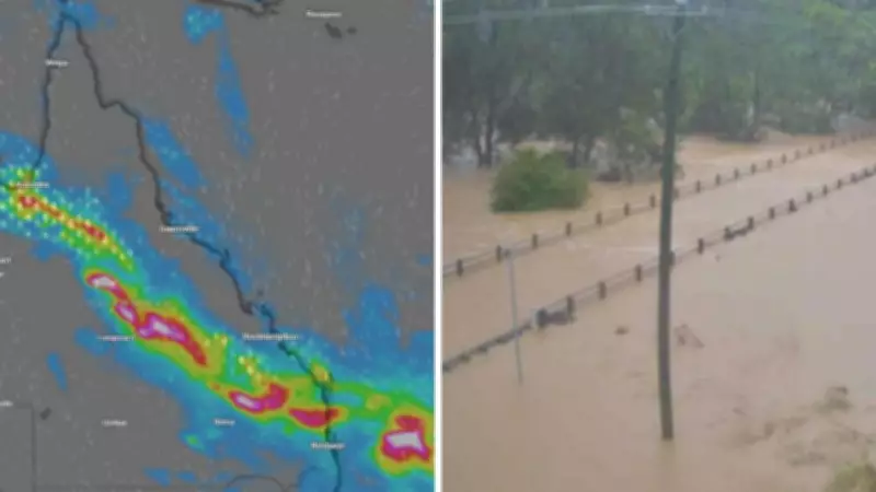
Extensive regions of Queensland have been submerged as a persistent band of heavy rain continues to batter the state, leading to widespread flooding and emergency situations. The Bureau of Meteorology has issued warnings, indicating that most of Queensland remains under watch, with potential for minor to moderate flooding across large areas and isolated major flooding in some parts. Heavy rainfall is forecast to persist over northern, central, and southeastern Queensland for the next several days, exacerbating the already critical conditions.
Rainfall Shifts South, Intensifying Flood Risks
According to senior meteorologist Helen Reid from the Bureau of Meteorology, the focus of the rainfall is gradually moving southward. "In the past day, we've observed the rainfall concentration across Queensland shifting south," she explained. "The heaviest falls are transitioning away from the north tropical coast and northern inland regions, moving towards the central and south-eastern coasts as well as the central interior." This shift has resulted in significant precipitation, particularly in the Wide Bay, Central Highlands, and Burnett areas, where some of the most intense rain occurred on Sunday afternoon.
Overnight, rainfall intensified north of the Sunshine Coast, primarily affecting the Wide Bay and Burnett districts. Reid noted that widespread totals ranged from 90mm to 100mm, with localized areas experiencing over 150mm. Notable rainfall figures recorded between 9am Sunday and 5am Monday include Bruvinia with 239mm, Boondamurapita with 209mm, and Karanga with 199mm, accompanied by very high rain rates and flash flooding in these zones.

Emergency Responses and Road Closures
Queensland police reported that the State Emergency Services received 54 calls for assistance from 6pm Sunday to Monday morning, with most requests related to flooding and structural damage in the South Burnett and Gympie regions. In response to the escalating situation, numerous roads have been closed due to flooding across the state's southeast, including Munduberra Durong Rd in Boondooma.
An emergency alert was issued by police around 9:30am on Monday for Rubyvale, urging residents to evacuate immediately. The alert stated, "Central Highlands Regional Council has issued an emergency warning for flash flooding in the Policemans Creek and Rubyvale area. Move to higher ground and warn others. There is an immediate threat to life and property." Similar alerts have been activated for Sapphire, with watch and act notices for Jandowae and Chinchilla.
The Boyne River at Cooranga is currently at 14.89m, significantly above the major flood level of 7m, according to the Bureau of Meteorology. Reid emphasized that Monday would be particularly wet across broad sections of central and south-east Queensland, driven by a low-pressure trough drawing in substantial moisture. A severe weather warning for heavy rainfall remains in effect, covering central interior and south-eastern parts of the state, highlighting risks of high rain rates and flash flooding throughout the day.
Forecast and Future Conditions
While showers and rain will impact southern areas like Brisbane and the Gold Coast, falls in these regions are expected to be more moderate, with heavier rain concentrated north of the Sunshine Coast. Reid indicated that the heaviest falls on Monday would depend on the movement of the low-pressure trough and the development of severe thunderstorms. There is also potential for locally intense rainfall in parts of the Wide Bay, Burnett, southern Capricornia, and central Highlands, which could lead to dangerous, life-threatening flash flooding.
The low-pressure trough is projected to move off the east coast late on Monday, taking the bulk of the heavy rain with it. "Through the early hours of Tuesday morning, conditions across south-east Queensland will trend back to scattered showers, with much lower rainfall totals forecast from Tuesday onwards," Reid added.

Northern Territory Also Affected by Flooding
In the Northern Territory, hundreds of people have been evacuated from outback communities such as Palumpa, Daly River, and Katherine due to severe flooding. On Sunday, police rescued a man from floodwaters in Beswick following major flash flooding of the Waterhouse River. Superintendent Virginia Read of the Northern Territory Police Force urged caution, stating, "The Northern Territory Police Force strongly urge people to stay out of flood waters. The risk of injury, sickness, and death are too high—if it's flooded, forget it."
The Katherine River is under a major flood warning, with levels peaking at 19.2m late Saturday evening, comparable to the 2006 flood level. As of 4:30am Monday, the level had dropped to 17.4m, just below the major flood threshold. At the Nitmiluk Centre, the river is approximately 4.6m above the minor flood level. The Daly River is also experiencing major flooding, with levels at the Daly River Police Station reaching 14.7m, well above the major flood mark.
Reid noted that the Daly River is rising slowly and may not peak for several days, with major flooding likely to persist throughout the week. Showers and thunderstorms are forecast for the Northern Territory in the coming days, with isolated heavy falls possible. Given saturated grounds and already swollen rivers, additional rainfall could cause further increases in flood levels, even in areas where water is beginning to recede.