
The Hunter Region experienced a year of dramatic climatic extremes in 2025, with long-standing weather records for both heat and rainfall shattered across multiple locations. Data from the Bureau of Meteorology reveals a pattern of intense conditions that pushed historical benchmarks to new limits.
Historic Heat: Overnight Temperatures Soar
One of the most striking trends was the record-breaking heat, particularly in minimum overnight temperatures. Paterson registered its hottest night since records began at the site in 1967. On December 22, the temperature failed to drop below 28.8 degrees Celsius, setting a new high for the lowest temperature recorded in a 24-hour period.
The heat was widespread. Williamtown also recorded its highest October temperature ever when the mercury hit 29.8 degrees on October 22. Furthermore, on December 22, Williamtown's overnight minimum was a record-breaking 25.7 degrees.

Cessnock experienced consecutive monthly overnight heat records towards the end of the year. The temperature remained at or above 22.6 degrees on November 26, followed by an even higher minimum of 26.7 degrees on December 22.
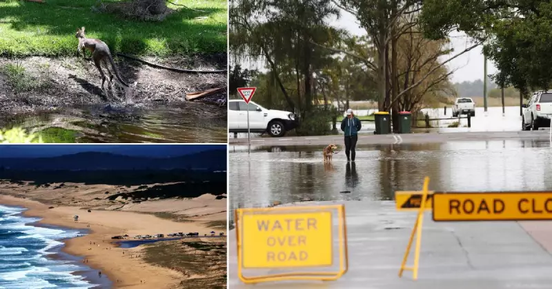
Unprecedented Rainfall and Flooding Events
While temperatures climbed, rainfall records were also being demolished, leading to significant flooding events in parts of the region. Paterson saw its August rainfall record broken with a total of 195.6mm for the month. This was heavily influenced by a daily deluge of 92.4mm on August 3, which itself set a new daily record for August at that location.
The rainfall intensity was even more pronounced at Williamtown's RAAF weather station. More than 500mm of rain fell in May 2025, making it the wettest May since records started there in 1942. A single day, May 23, contributed 149mm, setting a new daily record for May.
Cessnock recorded its wettest May and August since its weather station commenced operations in 1968. May brought 220mm of rain, including a daily record of 49.2mm on the 19th. August saw 176mm, with over half of that—101.8mm—falling on August 3, breaking the daily record for that month.
Outlook: A Trend of Warmer Conditions
The Bureau of Meteorology indicates that the trend of above-average temperatures is likely to persist. In a long-range forecast update for January to March, a bureau spokesperson stated that "days and nights are likely to be warmer than average for most of the country."
Looking further ahead, rainfall predictions show roughly equal chances of above or below-average rainfall for most Australian regions. However, parts of Queensland and New South Wales, which include the Hunter, have a slightly increased chance of experiencing above-average rainfall.
The data from 2025 paints a clear picture of a region grappling with more intense and record-setting weather events, a pattern that climate scientists and local authorities will be monitoring closely in the years to come.


