Cyclone Warning Issued for WA's North West Coast as Tropical Low Intensifies
A severe weather alert has been activated for a vast section of Western Australia's coastline, with authorities urging immediate preparations as a tropical low gains strength over the Kimberley region.
Widespread Impact Expected from Exmouth to Onslow
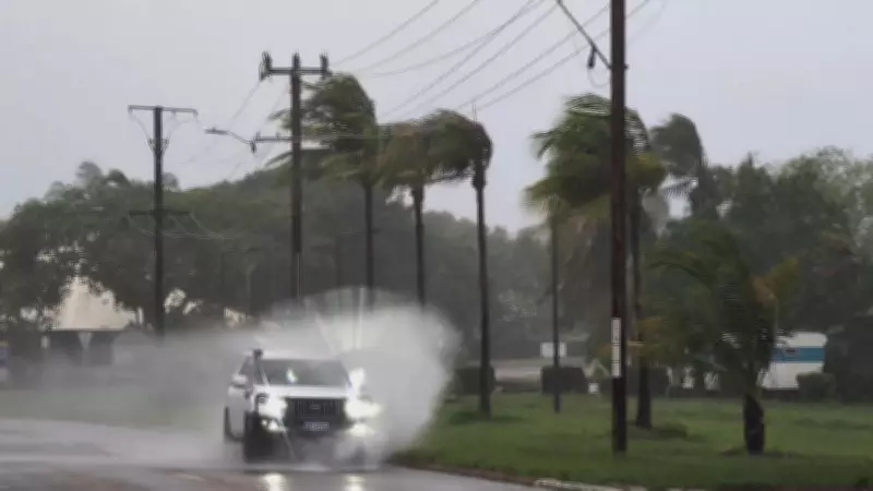
The Bureau of Meteorology has issued a tropical cyclone warning for residents stretching from Exmouth to Onslow, advising them to brace for potentially dangerous conditions this weekend. Forecasters predict wind gusts could reach up to 120 kilometres per hour, accompanied by heavy rainfall that may lead to flash flooding in vulnerable areas.
According to meteorological experts, the developing system is currently moving westward over the central Kimberley and is expected to move offshore by Friday. Once over water, the tropical low is forecast to intensify into a cyclone, tracking parallel to the Pilbara coast before potentially turning toward the coastline south of Exmouth.

Timeline of Severe Weather Events
The weather bureau anticipates widespread moderate to locally heavy rainfall beginning late Friday, with the most intense conditions expected on Saturday. The strongest wind gusts, potentially reaching 120km/h, are predicted to occur between Onslow and Port Hedland during this period.
Currently classified as a Tropical Low, the system is generating sustained winds near its centre of approximately 30km/h with gusts up to 75km/h. However, meteorologists warn that these conditions will intensify significantly as the system moves offshore and develops cyclonic characteristics.
Emergency Services Issue Urgent Preparation Advice
The Department of Fire and Emergency Services has issued specific warnings for communities between Onslow and Port Hedland, emphasising the need for immediate action. DFES Commissioner Darren Klemm stated, "This developing weather system requires serious attention from all residents in the warning area. Preparation time is limited, so we urge people to act now."
Emergency services recommend several crucial preparation steps:
- Secure all outdoor items including boats, caravans, trailers, garden sheds, outdoor furniture, rainwater tanks, LPG bottles, and loose materials
- Complete emergency kits with essential supplies for five to seven days
- Develop and discuss family emergency plans using official resources
- Monitor official warning systems regularly for updates
Essential Emergency Kit Components
DFES emphasises that properly prepared emergency kits should include:
- Canned food and sufficient water for five to seven days per person
- Comprehensive first aid kit and necessary medications
- Cash reserves for emergency situations
- Battery-operated radio with spare batteries for receiving warnings
- Important documents in waterproof containers
Residents are strongly advised to familiarise themselves with the four official cyclone warning levels and the specific actions required for each stage. The Emergency WA website and mobile application provide detailed guidance on preparation steps, real-time updates, and official evacuation routes if necessary.
Weather patterns in the region suggest this system may follow similar tracks to previous cyclones that have affected Western Australia's northwest coast. Historical data indicates that February typically marks the peak of cyclone season in this region, with systems often developing rapidly once they move over warm ocean waters.
Local authorities have activated their emergency response protocols and are coordinating with regional councils to ensure adequate resources are available. Additional personnel have been deployed to key locations, and emergency shelters are being prepared in case evacuation becomes necessary.
The Bureau of Meteorology will continue to monitor the system closely, providing regular updates as the situation develops. Residents should remain vigilant and follow official advice from emergency services throughout the weekend.