
New Cyclone Threat Looms Over Flood-Ravaged Queensland and Northern Territory
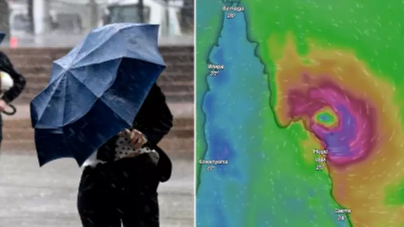
Flood-ravaged regions in Far North Queensland and the Northern Territory face the alarming prospect of another tropical cyclone as a new weather system brews off the tropical north coast. The Bureau of Meteorology (BOM) has reported that favourable weather conditions have sparked the development of a tropical low south of the Solomon Islands, which is forecast to strengthen as it approaches Queensland's coastline.
Cyclone Formation and Path Forecast
This system has a high probability of intensifying into a tropical cyclone by the end of the week. It is expected to barrel through the far north of Queensland before heading into the Gulf of Carpentaria and continuing over into the Northern Territory. If it does form, it will be designated as Tropical Cyclone Oran.
Senior meteorologist Livio Regano emphasized that even if the tropical low does not develop into a full cyclone, it will still bring unwanted rainfall to already sodden areas. "What's changed really quite dramatically in the last day or two is the certainty of its path," he stated. "Pretty much there's a really strong consensus with all weather model runs, they have it basically darting towards Cape York Peninsula with a crossing sometime late this week, maybe Friday, north of Cooktown somewhere."

Impacts on Flooded Communities
Regano warned that regardless of cyclone formation, the system will increase rainfall and wind for north Queensland. "North Queenslanders, I think, have had enough rain, don't need any more. So it's not great for them, all the catchments are wet," he said. The system is predicted to be compact and fast-moving as it enters the Gulf of Carpentaria, potentially bringing more flooding to the Top End and Central Australia.
This new threat comes as communities are still reeling from recent floods. In Katherine, Northern Territory, hundreds of people remain in shelters, some houses are without power, and crocodiles were spotted in floodwaters last week. The flooding in Katherine is the worst in almost 30 years, with Australian Defence Force members arriving to assist after a request from NT Chief Minister Lia Finocchiaro. Hundreds of residents from Daly River, Palumpa, Beswick, and Jilkminggan were airlifted to Darwin last weekend.
Seasonal Context and Clean-Up Efforts
Regano noted that the cyclone season is far from over, with March being one of the busiest times. "The season tends to peak late summer, early autumn so February, early March tends to be the peak, but right through March, especially when the waters are warm as they are now," he explained. "It is, you know, prime cyclone season, you really have to wait until towards the end of April before it starts settling down."
Meanwhile, clean-up efforts continue in other affected areas. Bundaberg in central Queensland is dealing with its third major flood in 16 years, though not as severe as the devastating 2013 event. Locals were evacuated late last week, leaving about 10,000 people isolated after major bridges were shut. Minor flooding persists along the Burnett River at Dunollie and Walla, with river levels slowly falling.
In the nearby Gympie region, a tragic discovery was made as police found the bodies of two Chinese backpackers who went missing in floodwaters last week. Their bodies were located in a submerged car near Kilkivan, where floods had inundated communities.
As the new weather system approaches, authorities urge residents in vulnerable areas to stay informed and prepared for potential impacts, highlighting the ongoing challenges faced by these regions during this active cyclone season.


