Bundaberg Residents Urged to "Act Now" as Major Flood Threat Looms
Residents in Bundaberg are being told to take immediate action as the region faces the threat of its most severe flooding event in over a decade. A major flood warning has been issued for the Burnett River, which is expected to reach 7 meters by 3pm on Tuesday before peaking at approximately 7.5 meters on Wednesday afternoon.
Flood Levels Comparable to Past Disasters
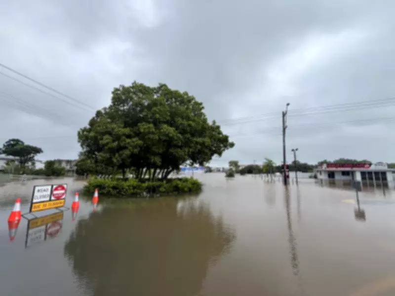
These projected water levels are alarmingly similar to the devastating floods that struck the region in 2010 and 2013, causing widespread damage and disruption. Flooding is already occurring across the catchment area, with waters having surpassed moderate flood levels.
"At the moment in Bundaberg we have seen the flood waters at the Burnett River have gone above moderate flood levels," Bureau of Meteorology senior meteorologist Daniel Hayes reported. "It is up about, or over, 5.5m now. We are expecting to see that reach major flood level this afternoon at 7m, and the potential is for a peak about 7.6m."

Hayes emphasized that major flooding is already occurring further up the river, with that water currently making its way downstream toward Bundaberg.
Emergency Preparations Underway
Heavy rainfall has been battering the region since Friday morning, prompting Bundaberg Regional Council to announce that both the Tallon and Burnett Bridges will be closed once the Burnett River reaches 7 meters. Evacuation centers have been opened, with the local council strongly urging residents who require support to reach out immediately.
The council stated: "Residents likely to have properties impacted by floodwaters can take refuge at the Bundaberg Recreational Precinct. The Main Pavilion at the precinct has been opened as a place of refuge by Bundaberg Regional Council in response to major flooding of the Burnett River."
Authorities are advising residents to "watch and act and prepare now to leave" if their properties may be affected by rising waters. Special attention is being given to individuals with medical needs, who are encouraged to relocate to the southern side of the river to maintain access to essential health services and in case of power outages.
Community Response and Business Preparations
Businesses in the CBD area have begun clearing out stock and preparing their properties for potential flooding. Sandbagging stations remain operational at SES facilities in Branyan and Bargara, while police, SES personnel, and Red Cross volunteers are preparing to conduct door-knocking campaigns in vulnerable northern suburbs to facilitate evacuations before bridge closures.
Widespread Flooding Across Queensland
Large portions of Queensland continue to experience significant flooding as a band of heavy rain slowly moves across the region. Most of the state remains on flood watch, with widespread minor to moderate flooding possible and isolated major flooding also a concern.
Some of the heaviest rainfall occurred on Sunday afternoon and into Monday morning across the Wide Bay, Central Highland, and Burnett regions. Notable rainfall totals include:
- 226mm in 24 hours at Hills Road between Gladstone and Bundaberg
- 250mm at Alligator Flats
- 211mm at Mount Mongrel
The State Emergency Service responded to 621 callouts across Queensland within 24 hours, with more than 200 calls originating from the Bundaberg region alone.
Weather System Moving Offshore
According to the Bureau of Meteorology, the rain is likely to contract offshore by Tuesday morning, leaving only seasonal coastal showers. "We've seen the low-pressure system that developed and pushed offshore has now moved well out into the ocean," Hayes explained. "It's having some impact out towards Norfolk Island at the moment, but well away from the mainland."
Despite this development, widespread flooding remains a significant concern as water continues to travel downstream from higher catchment areas and river systems. Hayes noted that "we did see significant rainfall on previous days with a number of stations sort of pushing up into that 200mm to 300mm range, for the two or three days that we saw the rain falling."

Saturated Catchments and Multiple Warnings
Catchments across Queensland are saturated from recent rainfall and will respond quickly to any additional heavy precipitation. Multiple minor to major flood warnings are currently active across the state, affecting numerous river systems including:
- Herbert, Haughton, and Burdekin downstream of Burdekin Falls Dam
- Don, Proserpine, Pioneer, Connors, and Isaac rivers
- Dawson, Baffle, Kolan, Burnett and their tributaries
- Burrum, Cherwell, Isis, Gregory, Elliott, and Mary rivers
- Noosa, Mooloolah, Upper Brisbane, Stanley, and lower Condamine
- Myall Creek and Charleys Creek
Additional warnings extend to the upper Balonne, Bungil Creek, Warrego, Paroo, Nicholson-Albert, Upper Flinders, Lower Flinders, Norman, Gilbert, Georgina and Eyre, Diamantina and Western River, Thomson, Barcoo and Cooper catchments.
Road closures have already been implemented, including Munduberra Durong Road in Boondooma, with multiple other roads affected by floodwaters across the region.