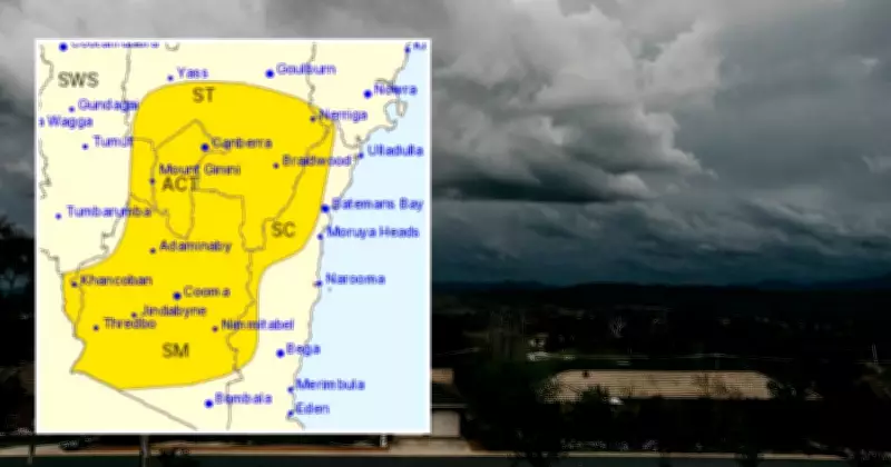
Severe Thunderstorms Forecast to Hit ACT and Southeast NSW
The Bureau of Meteorology has issued a severe thunderstorm warning for the Australian Capital Territory and southeast New South Wales, with forecasts predicting potentially damaging conditions across the region. Residents are urged to stay alert as the weather system approaches, bringing risks of strong winds, heavy rainfall, and large hail.
Weather Warning Details and Expected Impacts
According to the latest updates from meteorological authorities, the severe thunderstorms are expected to develop throughout the afternoon and evening. Key areas at risk include Canberra and surrounding suburbs in the ACT, as well as parts of southeast NSW such as Queanbeyan, Goulburn, and the Southern Tablelands. The Bureau warns that these storms could produce wind gusts exceeding 90 km/h, which may lead to fallen trees, power outages, and property damage.
In addition to the damaging winds, forecasters highlight the potential for heavy rainfall that could result in flash flooding in low-lying areas. Large hail is also a concern, with reports suggesting stones could reach sizes of up to 2 centimeters, posing risks to vehicles and outdoor structures. Emergency services have been placed on standby, and the public is advised to secure loose items and avoid unnecessary travel during the storm period.

Safety Precautions and Community Response
Local authorities are emphasizing the importance of safety measures as the severe weather unfolds. Residents should monitor official alerts from the Bureau of Meteorology and stay indoors if possible. It is recommended to keep away from windows, unplug electrical devices, and have emergency kits ready in case of power disruptions. Schools and businesses in the affected regions may implement contingency plans, with some already advising remote work or early closures to ensure public safety.
The community is encouraged to report any storm-related incidents to emergency services and to check on vulnerable neighbors, especially the elderly or those with limited mobility. This weather event follows a pattern of increased storm activity in the region, linked to broader climatic shifts that experts are closely monitoring. As the situation develops, further updates will be provided to keep the public informed and prepared.