The Australian Capital Territory is bracing for a severe and potentially destructive thunderstorm this afternoon, with the Bureau of Meteorology issuing an urgent warning for damaging winds, large hailstones, and heavy rainfall that could lead to flash flooding.
Immediate Threat to Northern Canberra
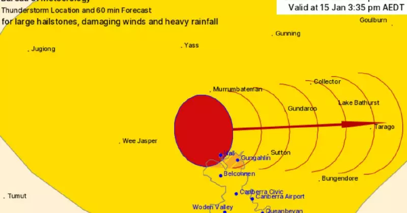
The Bureau of Meteorology (BOM) flagged the developing situation around 3pm on Thursday, January 15, 2026. The warning specifically highlighted a 'very dangerous storm' occurring southeast of Cooma, which is tracking towards the ACT.
Meteorologists predict the severe weather will affect northern parts of the capital, with Gungahlin expected to be impacted by 4:05 pm. Other warning areas include Hall, the Barton Highway between Murrumbateman and Hall, and the Kosciuszko National Park west of Lake Eucumbene.

The bureau advised that these thunderstorms are moving in an east to southeasterly direction. The unstable conditions are being driven by a surface trough interacting with a warm, moist atmosphere across New South Wales.
Emergency Services Issue Critical Safety Advice
The ACT State Emergency Service (SES) has released urgent safety instructions for residents in the path of the storm. Key advice includes securing loose items around properties, parking cars under cover away from trees, and staying indoors away from windows.
Critical safety steps from the SES include:
- Keep at least 8 metres away from fallen power lines and report them immediately to your energy provider.
- Avoid walking, riding, or driving through flood water.
- Seek refuge in the highest available place if trapped by flash flooding and call 000 for rescue.
- Keep children and pets indoors.
For emergency assistance in floods and storms, residents should ring the SES on 132 500. The public is urged to stay updated via the Hazards Near Me NSW app or the ACT ESA website.
Broader Warning Zone Across NSW Districts
While the immediate danger is focused on the ACT, a more general severe thunderstorm warning remains current for a wide swathe of New South Wales. This includes the Southern Tablelands, Snowy Mountains, and parts of the Illawarra, South Coast, Central Tablelands, and South West Slopes districts.
The Bureau of Meteorology has scheduled its next weather update for 4:35 pm. Authorities are urging all residents in the warning area to monitor conditions closely and prepare to enact their safety plans.