Far North Queensland on High Alert for Severe Weather and Potential Cyclone
Residents in Far North Queensland are being warned to prepare for heavy rainfall and potential flooding as a low pressure system off the coast of Cairns threatens to develop into a tropical cyclone as early as Friday. The system, identified as tropical low 29U, is currently situated about 400 kilometres to the northeast of Cairns in the Coral Sea and is expected to make landfall near the Innisfail area within the next 24 hours.
Meteorologists Issue Severe Weather Warnings
Senior meteorologist Jonathan How from the Bureau of Meteorology has indicated that severe weather conditions are likely to begin building from Friday morning. He stated, "We are already observing rain and storms developing to the north of Daintree and extending towards Cooktown. At this stage, there remains a moderate chance that this system could evolve into a tropical cyclone today or tomorrow." A tropical cyclone watch is currently in effect for communities spanning from Cooktown to Palm Island, including Port Douglas, Cairns, Innisfail, and Palm Island itself.
How emphasized that regardless of whether the system officially becomes a tropical cyclone, impacts similar to a category one system—such as heavy rain and damaging winds—are anticipated to affect the region. Track maps have been issued by the Bureau of Meteorology to monitor the possible cyclone's movement as it approaches the coastline.

Potential Cyclone Naming and Immediate Impacts
If the system does intensify into a tropical cyclone, it is likely to be named Narelle or Owen. Rainfall is expected to increase from Thursday afternoon into the evening across the northeast tropical coast, including areas around Cairns and further south, as the system draws closer. How added, "We are forecasting gale force winds to develop along the coast starting early Friday morning, extending throughout the cyclone watch area."
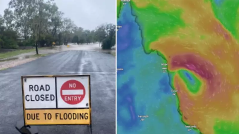
He further warned, "Heavy rainfall is anticipated as the system crosses the coast on Friday, which could lead to flash flooding and higher than normal tides, potentially exceeding the highest tide of the year." Weather models, such as those from Windy.com, show the possible cyclone's progression on Thursday afternoon, highlighting the urgency of the situation.
Broader Rainfall and Flooding Concerns Across Queensland
The system is projected to bring rainfall more broadly across Queensland, with heavy rain extending as far south as Mackay and Rockhampton by Saturday. On Sunday, moderate to heavy falls could impact eastern parts of the state, later shifting towards central and south-eastern Queensland. Depending on the system's trajectory, heavy falls may also occur around the Wide Bay and Brisbane areas.
How noted that while conditions are expected to gradually ease for northern Queensland later in the weekend and early next week, flooding issues could persist for an extended period. "We are reminding residents that flooding problems may continue for quite some time, and this upcoming heavy rainfall could prolong existing flooding across the region," he said. Authorities urge residents to stay informed and take necessary precautions to ensure safety during this severe weather event.