Ex-Tropical Cyclone Koji crossed the north Queensland coast near Ayr on Sunday morning, weakening into a tropical low-pressure system. Despite the downgrade, authorities warned that heavy rainfall and flash flooding remain significant concerns for the region.
The Bureau of Meteorology (BOM) predicted some areas could see up to 340 millimetres of rain in the next 24 hours. Coastal areas between Ayr and St Lawrence were expected to experience the worst weather on Sunday, with the danger zone extending south towards Rockhampton from Monday.
Several flood warnings remained in place, including for Finch Hatton and Eungella west of Mackay. Major flood warnings were issued for the Pioneer River, Georgina River and Flinders River catchments. The heaviest falls recorded included 362mm at Clarke Range in 24 hours and 370mm at Cattle Creek in 12 hours.

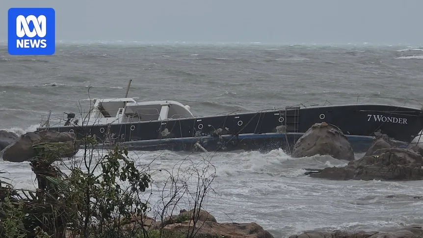
Strong winds and rough seas caused boats to break free from anchorages, with one yacht running aground at Airlie Beach. Two men swam to safety after their boat sank near Pigeon Island. Five children and two adults were rescued from a home in Finch Hatton after being trapped by rising creek waters.
Queensland Premier David Crisafulli said crews were working to restore power to about 22,000 homes, mainly in the Mackay and Whitsundays regions. The Bruce Highway reopened at Peter's Flat north of Bowen, but motorists were urged to proceed with caution due to water over the road.
BOM forecaster Angus Hines described the system as 'lopsided', with most rainfall dumped south of the storm. He warned of persistent heavy rain and potential flooding on the southern flank, with six-hourly totals up to 150mm possible.