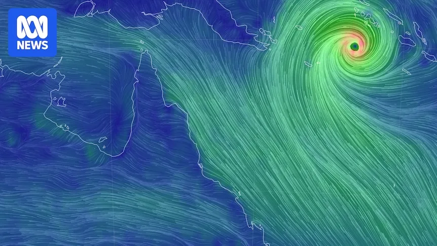
Severe Tropical Cyclone Maila, now a category five system, is expected to cross Cape York Peninsula from Sunday, but its exact landfall location remains uncertain. The cyclone is currently about 980 kilometres east of Port Moresby, Papua New Guinea, with wind gusts up to 295 km/h.
Senior forecaster Liam Smart from the Bureau of Meteorology said Maila is larger but less intense than ex-Tropical Cyclone Narelle, which hit the region last month. The system is forecast to weaken as it passes over Papua New Guinea's mountain ranges and into the cooler Coral Sea before reaching the Cape York Peninsula late Sunday.
Rainfall associated with the cyclone is expected to be largely confined to the Far North, though there is potential for extra rainfall on the north tropical coast after the cyclone crosses. Communities in Cape York are still recovering from Cyclone Narelle, with ongoing road washouts hampering efforts.

Tourism operators, concerned about unnecessary cancellations, are urging visitors not to abandon their travel plans. Port Douglas operator Jason Heffernan noted that many tourists mistakenly believe the entire region is affected, when the cyclone's impact is far north. He emphasized that the distance from Port Douglas to the cyclone's path is similar to that from Melbourne to Canberra.
Cook Shire Mayor Robyn Holmes said preparation is underway for another severe weather event, prioritizing life and property. She noted that many landholders have not yet fully assessed damage from Cyclone Narelle, with some facing over 500 kilometres of fence line repairs.