Perth's WA Day long weekend remained wet and wild on Sunday, with the city experiencing heavy rainfall and damaging winds. More than 20mm of rain fell by 5pm on Sunday, as intense showers swept across the west coast from the Midwest to the Great Southern regions.
Wind Gusts and Damage
Wind gusts reached 113kph on Rottnest Island in the mid-afternoon, while Cape Leeuwin recorded a gust of 122kph. The winds were expected to worsen as the evening progressed before easing after midnight. The destruction began on Saturday night, with over 120 calls made to the State Emergency Service between 5pm Saturday and 9am Sunday. The damage continued throughout the day as winds intensified.
Another 160 calls to the SES were made before 4pm on Sunday, primarily from the metropolitan area but also extending to the South West, Great Southern, and Midwest-Gascoyne regions. While areas in Perth's south were initially hit hard, coastal regions including Mandurah and Bunbury experienced the worst impacts.

Power Outages and Fallen Trees
Numerous trees and power lines fell across the state, leaving nearly 30,000 households without power in Perth and the wider South West of WA. Western Power predicted that affected homes might have to wait until Monday evening for electricity to be restored.
Bureau of Meteorology spokesman Joey Rawson noted the unusual intensity of the storm. "The unusual aspect of this system is that the low pressure system producing these exceptionally windy conditions is more intense than usual," he said. "It's conditions that we don't see that often; we won't see an event like this for a number of years."
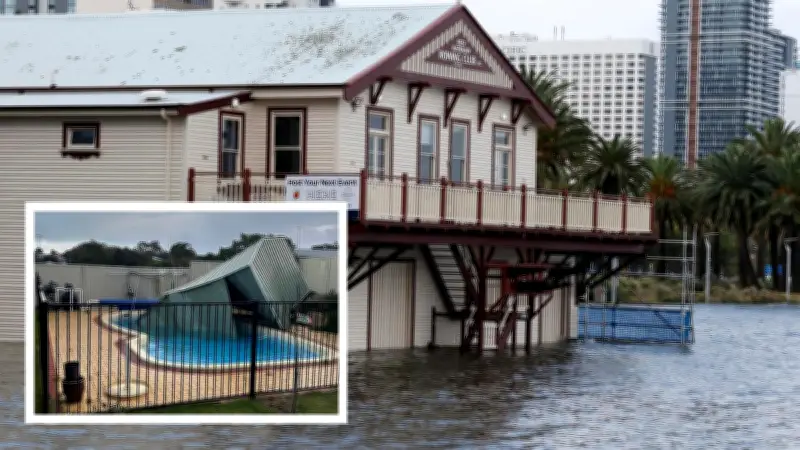
Backyard Damage and High Tides
The storm also affected backyard fixtures that were not properly secured. Mandurah resident Matt Atley found a neighbor's shed bent and lying in his pool after the wild weather. He shared the incident on social media, asking, "Anyone in Mandurah is missing a shed from last night's storm? We found it."
Unusually high tides were observed across the city on Sunday morning. The Swan River's water level reached 1.9 metres at Barrack Street, more than half a metre above normal. The walkway to the iconic Blue Boat Shed was entirely submerged. Mr. Rawson stated that water levels were expected to recede by Monday.
"There's certainly been some storm surge along the West Coast, and that coincided with the high tide that occurred this morning," he said. "That also brought water in on the Mitchell Freeway and Riverside Drive. However, those storm surge conditions along the west coast are going to ease for tomorrow's high tide, so the worst is done regarding water inundation for tomorrow. But along the south coast, there's potential for water inundation in places like Albany as the system tracks further east south of WA."
Beach Erosion and Transport Disruptions
Beaches also bore the brunt of the storm, with some in Rockingham showing considerable erosion. Similar conditions were reported along the coast from Lancelin to Busselton, with high tides affecting these areas.
The wet weather caused disruptions to public transport, with a storm-related technical issue leading to cancellations on the Fremantle line and delays on the Midland line. Transport Minister Rita Saffioti warned commuters via social media, stating, "The Public Transport Authority is working as quickly as possible to resolve the issues and will continue to monitor the situation across the network as the storms continue to cross the state. Thank you to all our frontline workers who are out in the storm helping clean up and managing the impacts."
WA Day Festivals Cancelled
The weather was expected to ease for the final day of the long weekend, but not enough to prevent the cancellation of several WA Day festivals planned for the public holiday. A statement from organizers Celebrate WA read, "Strong winds are making it impossible to safely bump in the event, and conditions are not expected to improve sufficiently for a public event of this scale to proceed safely. The safety of patrons, performers, artists, vendors, staff, volunteers, and event partners is always the overriding priority."

The weather system wreaking havoc on the west coast is expected to continue moving eastwards towards the eastern states, providing some relief to Perth. However, Mr. Rawson warned that WA's south-east region would still feel the storm's effects. "We've got this intense tropical low just southwest of WA, and that is going to move eastwards," he said. "With that intense tropical low, it's bringing damaging and destructive wind gusts, especially to west coast towns south of Lancelin and south coast towns as that system continues to move east. The west coast conditions will ease through Monday morning, but southern districts will continue to get some damaging and possibly destructive wind gusts as we progress through Monday."