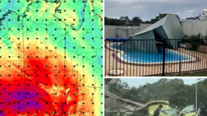
Millions of Australians are bracing for destructive winds to sweep across multiple states, following a rare weather event that pounded Western Australia with 135km/h wind gusts. The powerful low-pressure system, which caused widespread power outages and coastal damage in WA, is now moving eastward, threatening South Australia and Victoria with brutal winds of up to 100km/h.
Severe Weather Warning for South Australia
A severe weather warning remains in effect for large parts of South Australia, with the Bureau of Meteorology cautioning against damaging wind gusts, hazardous coastal conditions, and potential infrastructure impacts. Bureau meteorologist Angus Hines stated that the broad low-pressure system crossing the Great Australian Bight would bring the strongest impacts to South Australia on Monday before shifting east overnight.
“For South Australia, almost all southern areas are in warning for damaging wind gusts, mostly on Monday,” Mr. Hines said. “For Adelaide, it’s likely to be Monday evening, pushing into early Tuesday morning, where the wind is strongest. 90 to 100 km/h wind gusts are possible.”

While rain will accompany the system, the primary concern remains the wind. “For the most part in the next few days, while a lot of places will get some rain associated with this weather system, the rain isn’t forecast to be heavy and we don’t forecast a significant flood risk in most areas,” Mr. Hines explained. “What could be more significant than the wet weather will be the windy weather.”
Coastal Hazard Warning Issued
A Coastal Hazard Warning has been issued for parts of South Australia and western Victoria, with abnormally high tides and large waves expected to peak on Tuesday afternoon. The warning stretches from the Nullarbor coast and Ceduna through the Eyre and Yorke Peninsulas, Adelaide’s coastline, the Limestone Coast, and into western Victoria. Mr. Hines warned that the combination of powerful waves and elevated sea levels could lead to coastal erosion and localised inundation.
“We certainly could see some flooded roads, car parks, walkways, and bike paths along the ocean there, and potentially in a couple of spots where it’s worse, we could see some water pushing into and onto property,” he said.
Wild Weather Batters Western Australia
The same weather system left a trail of destruction across southern Western Australia over the weekend, with emergency crews responding to fallen trees, damaged power infrastructure, and coastal impacts. Bureau meteorologist Alana Cherny described the system as one of the strongest seen in some time. “This is an unusually deep low-pressure system, the likes of which we haven’t seen for quite a few years,” she said.
The strongest recorded wind gusts included 135km/h at Cape Naturaliste, 133km/h at Cape Leeuwin, and 120km/h at Busselton. Perth recorded a gust of 93km/h, while locations further east including Ravensthorpe and Mount Barker also approached 100km/h. While conditions have eased across the southwest, damaging winds are continuing east of Albany and south of Kalgoorlie on Monday.
“We’re looking at sustained winds of 60 to 70 km/h with gusts up to 100 km/h,” Ms. Cherny said. She added that damaging surf, coastal erosion, and abnormally high tides remained a concern along parts of the west and south coasts. “We will continue to see some impacts from this severe weather today, including some trees down with possible damage to property. We could see some more power lines down, bringing further power outages. And those coastal conditions continue to bring the risk of coastal erosion and inundation of low-lying coastal areas.”
NSW and Victoria Next in Line
The weather system is forecast to move into Victoria on Monday night before affecting parts of New South Wales on Tuesday. Victoria’s warning area includes parts of the Otway Coast, the Mornington and Bellarine peninsulas, northern Melbourne suburbs, and the state’s northeast ranges. In NSW, damaging winds are forecast for parts of the Snowy Mountains, Southern Tablelands, and Blue Mountains, including Katoomba and Oberon, with wind gusts of up to 100km/h possible. The highest peaks of the Snowy Mountains could experience gusts up to 125km/h, along with snow and blizzard-like conditions.

“Anyone at those highest elevations, absolutely please do take care,” Mr. Hines urged.