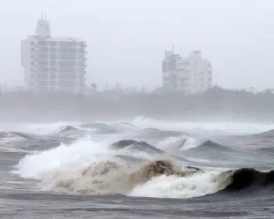
South-west Australia is bracing for a wet and windy week as multiple cold fronts are expected to drive intense rain and strong winds across the region over the coming days.
Cold Fronts Sweep Through
Cold and wet weather set in over Monday for southern parts of Western Australia as the first of several fronts swept through the state. Sky News Weather Meteorologist Tamsin Green explained that some local spots measured nearly 30 millimetres of rain in just 30 minutes, with strong wind gusts adding to the wild conditions.
"Taking a look at those wind gusts, we've seen them ramp up through Monday daytime and into the early hours of Tuesday, as well; they'll continue to strengthen," she added.

Warnings and Swells
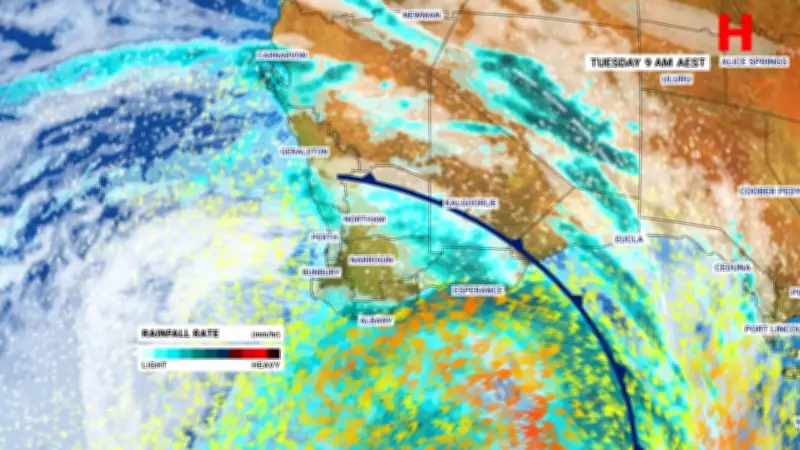
The Bureau of Meteorology has issued a gale warning for the Leeuwin Coast, Albany Coast, Esperance Coast, and Eucla Coast on Tuesday. Strong winds are also expected in Perth Local Waters, the Gascoyne Coast, Geraldton Coast, Lancelin Coast, Perth Coast, and Bunbury Geographe Coast.
High winds are driving major swells off the southern WA coast, reaching as high as seven metres in some areas, prompting warnings for anyone considering venturing out into the surf.
Continued Wet Weather
Wet and wild conditions are set to persist over Tuesday and beyond, according to Green. Another front is forecast to sweep through southern Australia over the remainder of the week.
"In terms of temperatures, it's that second cold front that's going to bring a more noticeable drop through to Tuesday morning," she said. "Not only is it a stronger cold front, but also, because of the strength of those winds, it will really take the edge off those temperatures, feeling around five to seven degrees lower than what the thermometer is actually recording."
Rainfall should ease for coastal parts of southern WA as the front moves east during the afternoon, although inland areas will likely then bear the brunt of any further wet weather. Western parts of South Australia may see showers in the late evening as the system continues to push across the country into Wednesday and Thursday.
National Forecast for Tuesday
Sydney
Patchy showers are possible throughout the morning in Sydney, before conditions clear in the afternoon. A high of 21 degrees is forecast for the Harbour City.
Melbourne
Melbourne locals can expect a windy, but mostly sunny day on Tuesday. Victoria's capital should reach a top of 19 degrees.
Brisbane
Light rain is expected throughout the day for Brisbane, along with grey skies. A high of 22 degrees is expected in the Queensland capital.
Canberra
Canberrans could be in for a frosty start to the day, with fog and cloudy conditions likely. Cool temperatures are forecast, with the mercury not expected to top 16 degrees.
Adelaide
A mostly sunny Tuesday is forecast for South Australia's capital. Brief showers are possible in the evening, but conditions will be otherwise mild, and temperatures could reach a high of 20 degrees.
Hobart
Hobart residents are in for a bright and sunny day. A top of 17 degrees is expected in Tasmania's capital.
Perth
Wet and windy conditions are set to continue for Perth on Tuesday. Despite the wild weather, temperatures are forecast to be mild, with the mercury likely to reach a high of 17 degrees.
Darwin
Patchy clouds and some gusty winds are expected in Darwin. A warm top of 31 degrees is forecast for the Northern Territory capital.